Cagnano Varano geodata
Cagnano Varano (Apulia) is a seat of a third-order administrative division; located in Italy in Europe/Rome (GMT+2) time zone. With population of 7,309 people, there are 1332 cities with bigger population in this country. Compared to other cities in Italy, 71.8% of cities are located further ↑North; 91.6% of cities are located further ←West and 60.9% of cities have higher elevation than Cagnano Varano. Note1


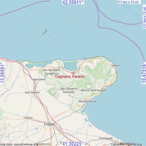
Cagnano Varano GPS coordinates[2]
41° 49' 41.952" North, 15° 46' 19.308" East
| Map corner | latitude | longitude |
|---|---|---|
| Upper-left | 42.35011°, | 15.06891° |
| Center: | 41.82832°, | 15.77203° |
| Lower-right: | 41.30225°, | 16.47516° |
| Map W x H: | 116.5×116.5 km | = 72.4×72.4mi |
| max Lat: | 47.04031° ⇑71.8% North |
| Cagnano Varano: | 41.82832° |
| min Lat: | ⇓28.2% South 35.50142° |
| min Long | Cagnano Varano | max Long |
| 6.69888° | 15.77203° | 18.48682° |
| W 91.6%⇐ | ⇒8.4% E |
Elevation
Elevation of Cagnano Varano is 156 m = 512 ft, and this is 150.7 m = 494 ft below average elevation for this country.
| Max E: |
2085 m = 6841 ft | 60.9% |
| Avg. | 306.7 m = 1006 ft | |
| Cagnano Varano | 156 m = 512 ft | |
Min E: |
-4 m = -13 ft | 39.1% |
See also: Italy elevation on elevation.city.
Geographical zone
Cagnano Varano is located in North temperate zone (between Tropic of Cancer and the Arctic Circle). Distance of this Northern Tropic circle is 2045 km =1270.7 mi to South.| Distance of | km | miles | from Cagnano Varano |
|---|---|---|---|
| North Pole | 5356.2 | 3328.2 | to North |
| Arctic Circle | 2750.3 | 1709 | to North |
| Tropic Cancer | 2045 | 1270.7 | to South |
| Equator | 4650.9 | 2889.9 | to South |


Nearby cities:
15 places around Cagnano Varano: (largest is in red/bold)
• Apricena
27.6 km =17.1 mi,  260°
260°
• Borgo Celano
16.8 km =10.4 mi,  214°
214°
• Carpino
7.3 km =4.5 mi,  75°
75°
• Ischitella
13.5 km =8.4 mi,  51°
51°
• Manfredonia
25.1 km =15.6 mi,  151°
151°
• Mattinata
26.5 km =16.5 mi,  119°
119°
• Monte Sant'Angelo
20.8 km =12.9 mi,  131°
131°
• Peschici
24 km =14.9 mi,  57°
57°
• Rignano Garganico
22.5 km =14 mi,  222°
222°
• Rodi Garganico
14.3 km =8.9 mi,  39°
39°
• San Giovanni Rotondo
14 km =8.7 mi,  195°
195°
• San Marco in Lamis
17 km =10.6 mi, 220°
• Sannicandro Garganico
17.2 km =10.7 mi,  273°
273°
• Vico del Gargano
17.1 km =10.6 mi, 63°
• Vieste
33.6 km =20.9 mi, 79°
Sources, notices
• [Note1] Compared only with cities in Italy existing in our database
• [Src1] Map data: © OpenStreetMap contributors (CC-BY-SA)
• [Src2] Other city data from geonames.org with taken over terms of usage.
• [Src3] Geographical zone / Annual Mean Temperature by Robert A. Rohde @ Wikipedia
