Carassai geodata
Carassai (The Marches) is a seat of a third-order administrative division; located in Italy in Europe/Rome (GMT+2) time zone. With population of 587 people, there are 9116 cities with bigger population in this country. Compared to other cities in Italy, 63.1% of cities are located further ↑North; 75.5% of cities are located further ←West and 62.8% of cities have lower elevation than Carassai. Note1
Administrative division(s):
- Level 1: The Marches
- Level 2: Provincia di Ascoli Piceno
- Level 3: Carassai


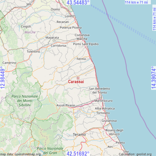
Carassai GPS coordinates[2]
43° 1' 58.908" North, 13° 41' 15.396" East
| Map corner | latitude | longitude |
|---|---|---|
| Upper-left | 43.54483°, | 12.98449° |
| Center: | 43.03303°, | 13.68761° |
| Lower-right: | 42.51692°, | 14.39074° |
| Map W x H: | 114.3×114.3 km | = 71×71mi |
| max Lat: | 47.04031° ⇑63.1% North |
| Carassai: | 43.03303° |
| min Lat: | ⇓36.9% South 35.50142° |
| min Long | Carassai | max Long |
| 6.69888° | 13.68761° | 18.48682° |
| W 75.5%⇐ | ⇒24.5% E |
Elevation
Elevation of Carassai is 321 m = 1053 ft, and this is 14.3 m = 47 ft above average elevation for this country.
| Max E: |
2085 m = 6841 ft | 37.2% |
| Carassai | 321 m 1053 ft | |
| Avg. | 306.7 m = 1006 ft | |
Min E: |
-4 m = -13 ft | 62.8% |
See also: Italy elevation on elevation.city.
Geographical zone
Carassai is located in North temperate zone (between Tropic of Cancer and the Arctic Circle). Distance of this Northern Tropic circle is 2178.9 km =1353.9 mi to South.| Distance of | km | miles | from Carassai |
|---|---|---|---|
| North Pole | 5222.2 | 3244.9 | to North |
| Arctic Circle | 2616.3 | 1625.7 | to North |
| Tropic Cancer | 2178.9 | 1353.9 | to South |
| Equator | 4784.8 | 2973.1 | to South |


Nearby cities:
15 places around Carassai: (largest is in red/bold)
• Cossignano
5.5 km =3.4 mi,  177°
177°
• Massignano
9.2 km =5.7 mi,  77°
77°
• Montalto delle Marche
8.1 km =5 mi,  233°
233°
• Monte Giberto
7.9 km =4.9 mi,  324°
324°
• Monte Rinaldo
8.6 km =5.3 mi,  266°
266°
• Monte Vidon Combatte
4.9 km =3 mi,  291°
291°
• Montefiore dell'Aso
5.9 km =3.7 mi,  68°
68°
• Monterubbiano
6.4 km =4 mi,  23°
23°
• Montottone
8.6 km =5.3 mi, 292°
• Moresco
6.9 km =4.3 mi,  30°
30°
• Ortezzano
6.7 km =4.2 mi, 267°
• Petritoli
4.4 km =2.7 mi,  333°
333°
• Ponzano di Fermo
8.2 km =5.1 mi,  343°
343°
• Ripatransone
7.1 km =4.4 mi,  121°
121°
• Rubbianello
3.7 km =2.3 mi,  35°
35°
Sources, notices
• [Note1] Compared only with cities in Italy existing in our database
• [Src1] Map data: © OpenStreetMap contributors (CC-BY-SA)
• [Src2] Other city data from geonames.org with taken over terms of usage.
• [Src3] Geographical zone / Annual Mean Temperature by Robert A. Rohde @ Wikipedia
