Vernole geodata
Vernole (Apulia) is a seat of a third-order administrative division; located in Italy in Europe/Rome (GMT+2) time zone. With population of 2,813 people, there are 3200 cities with bigger population in this country. Compared to other cities in Italy, 85.7% of cities are located further ↑North; 99.6% of cities are located further ←West and 83.4% of cities have higher elevation than Vernole. Note1


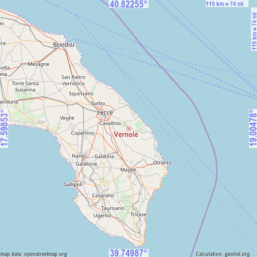
Vernole GPS coordinates[2]
40° 17' 18.024" North, 18° 18' 5.94" East
| Map corner | latitude | longitude |
|---|---|---|
| Upper-left | 40.82255°, | 17.59853° |
| Center: | 40.28834°, | 18.30165° |
| Lower-right: | 39.74987°, | 19.00478° |
| Map W x H: | 119.3×119.3 km | = 74.1×74.1mi |
| max Lat: | 47.04031° ⇑85.7% North |
| Vernole: | 40.28834° |
| min Lat: | ⇓14.3% South 35.50142° |
| min Long | Vernole | max Long |
| 6.69888° | 18.30165° | 18.48682° |
| W 99.6%⇐ | ⇒0.40000000000001% E |
Elevation
Elevation of Vernole is 36 m = 118 ft, and this is 270.7 m = 888 ft below average elevation for this country.
| Max E: |
2085 m = 6841 ft | 83.4% |
| Avg. | 306.7 m = 1006 ft | |
| Vernole | 36 m = 118 ft | |
Min E: |
-4 m = -13 ft | 16.6% |
See also: Italy elevation on elevation.city.
Geographical zone
Vernole is located in North temperate zone (between Tropic of Cancer and the Arctic Circle). Distance of this Northern Tropic circle is 1873.7 km =1164.3 mi to South.| Distance of | km | miles | from Vernole |
|---|---|---|---|
| North Pole | 5527.4 | 3434.6 | to North |
| Arctic Circle | 2921.5 | 1815.3 | to North |
| Tropic Cancer | 1873.7 | 1164.3 | to South |
| Equator | 4479.6 | 2783.5 | to South |


Nearby cities:
15 places around Vernole: (largest is in red/bold)
• Acquarica
2.3 km =1.4 mi,  30°
30°
• Borgagne
8.3 km =5.2 mi,  129°
129°
• Calimera
4.7 km =2.9 mi,  203°
203°
• Caprarica di Lecce
5.8 km =3.6 mi,  237°
237°
• Castri di Lecce
3.7 km =2.3 mi, 243°
• Cavallino
8.8 km =5.5 mi,  286°
286°
• Galugnano
8.2 km =5.1 mi, 244°
• Lizzanello
6.9 km =4.3 mi, 285°
• Martano
9.6 km =6 mi,  179°
179°
• Martignano
6.8 km =4.2 mi,  214°
214°
• Melendugno
3.5 km =2.2 mi,  119°
119°
• Merine
8.3 km =5.2 mi,  307°
307°
• Pisignano
3.1 km =1.9 mi, 305°
• Sternatia
9.8 km =6.1 mi,  219°
219°
• Strudà
3.9 km =2.4 mi,  334°
334°
Sources, notices
• [Note1] Compared only with cities in Italy existing in our database
• [Src1] Map data: © OpenStreetMap contributors (CC-BY-SA)
• [Src2] Other city data from geonames.org with taken over terms of usage.
• [Src3] Geographical zone / Annual Mean Temperature by Robert A. Rohde @ Wikipedia
