Malnate geodata
Malnate (Lombardy) is a seat of a third-order administrative division; located in Italy in Europe/Rome (GMT+2) time zone. With population of 15,466 people, there are 588 cities with bigger population in this country. Compared to other cities in Italy, 85.5% of cities are located further ↓South; 83.1% of cities are located further →East and 66.7% of cities have lower elevation than Malnate. Note1


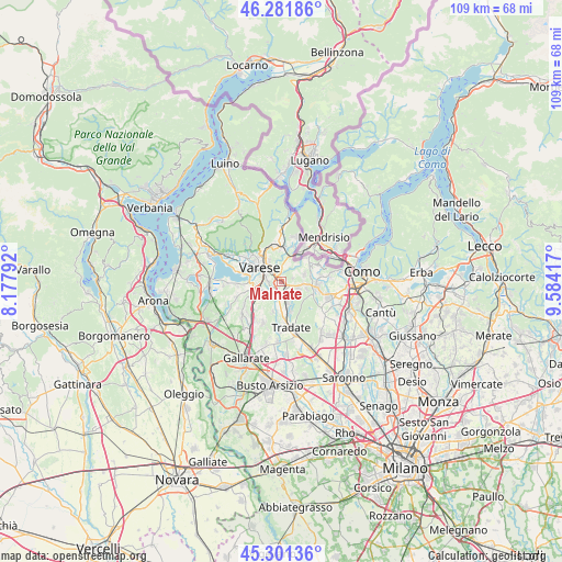
Malnate GPS coordinates[2]
45° 47' 37.572" North, 8° 52' 51.744" East
| Map corner | latitude | longitude |
|---|---|---|
| Upper-left | 46.28186°, | 8.17792° |
| Center: | 45.79377°, | 8.88104° |
| Lower-right: | 45.30136°, | 9.58417° |
| Map W x H: | 109×109 km | = 67.7×67.7mi |
| max Lat: | 47.04031° ⇑14.5% North |
| Malnate: | 45.79377° |
| min Lat: | ⇓85.5% South 35.50142° |
| min Long | Malnate | max Long |
| 6.69888° | 8.88104° | 18.48682° |
| W 16.9%⇐ | ⇒83.1% E |
Elevation
Elevation of Malnate is 360 m = 1181 ft, and this is 53.3 m = 175 ft above average elevation for this country.
| Max E: |
2085 m = 6841 ft | 33.3% |
| Malnate | 360 m 1181 ft | |
| Avg. | 306.7 m = 1006 ft | |
Min E: |
-4 m = -13 ft | 66.7% |
See also: Italy elevation on elevation.city.
Geographical zone
Malnate is located in North temperate zone (between Tropic of Cancer and the Arctic Circle). Distance of this North polar circle is 2309.4 km =1435 mi to North.| Distance of | km | miles | from Malnate |
|---|---|---|---|
| North Pole | 4915.3 | 3054.2 | to North |
| Arctic Circle | 2309.4 | 1435 | to North |
| Tropic Cancer | 2485.9 | 1544.7 | to South |
| Equator | 5091.8 | 3163.9 | to South |


Nearby cities:
15 places around Malnate: (largest is in red/bold)
• Albiolo
4.7 km =2.9 mi,  73°
73°
• Beregazzo con Figliaro
5.1 km =3.2 mi,  106°
106°
• Binago
3.5 km =2.2 mi, 111°
• Cagno
3.4 km =2.1 mi,  55°
55°
• Cantello
3.4 km =2.1 mi,  19°
19°
• Castiglione Olona
4.6 km =2.9 mi,  187°
187°
• Concagno
2.3 km =1.4 mi, 74°
• Gazzada Schianno
4 km =2.5 mi,  247°
247°
• Gornate Superiore
4.7 km =2.9 mi,  199°
199°
• Lozza
2.7 km =1.7 mi,  221°
221°
• Rodero
4.3 km =2.7 mi,  38°
38°
• Solbiate
4.1 km =2.5 mi,  96°
96°
• Valmorea
4.5 km =2.8 mi, 58°
• Vedano Olona
2.1 km =1.3 mi,  165°
165°
• Venegono Superiore
4.8 km =3 mi,  164°
164°
Sources, notices
• [Note1] Compared only with cities in Italy existing in our database
• [Src1] Map data: © OpenStreetMap contributors (CC-BY-SA)
• [Src2] Other city data from geonames.org with taken over terms of usage.
• [Src3] Geographical zone / Annual Mean Temperature by Robert A. Rohde @ Wikipedia
