Rodero geodata
Rodero (Lombardy) is a seat of a third-order administrative division; located in Italy in Europe/Rome (GMT+2) time zone. With population of 1,102 people, there are 6286 cities with bigger population in this country. Compared to other cities in Italy, 86.8% of cities are located further ↓South; 82.5% of cities are located further →East and 71.3% of cities have lower elevation than Rodero. Note1


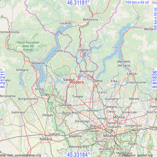
Rodero GPS coordinates[2]
45° 49' 26.328" North, 8° 54' 54.828" East
| Map corner | latitude | longitude |
|---|---|---|
| Upper-left | 46.31181°, | 8.21211° |
| Center: | 45.82398°, | 8.91523° |
| Lower-right: | 45.33184°, | 9.61836° |
| Map W x H: | 109×109 km | = 67.7×67.7mi |
| max Lat: | 47.04031° ⇑13.2% North |
| Rodero: | 45.82398° |
| min Lat: | ⇓86.8% South 35.50142° |
| min Long | Rodero | max Long |
| 6.69888° | 8.91523° | 18.48682° |
| W 17.5%⇐ | ⇒82.5% E |
Elevation
Elevation of Rodero is 407 m = 1335 ft, and this is 100.3 m = 329 ft above average elevation for this country.
| Max E: |
2085 m = 6841 ft | 28.7% |
| Rodero | 407 m 1335 ft | |
| Avg. | 306.7 m = 1006 ft | |
Min E: |
-4 m = -13 ft | 71.3% |
See also: Italy elevation on elevation.city.
Geographical zone
Rodero is located in North temperate zone (between Tropic of Cancer and the Arctic Circle). Distance of this North polar circle is 2306 km =1432.9 mi to North.| Distance of | km | miles | from Rodero |
|---|---|---|---|
| North Pole | 4911.9 | 3052.1 | to North |
| Arctic Circle | 2306 | 1432.9 | to North |
| Tropic Cancer | 2489.2 | 1546.7 | to South |
| Equator | 5095.1 | 3165.9 | to South |


Nearby cities:
15 places around Rodero: (largest is in red/bold)
• Albiolo
2.8 km =1.7 mi,  137°
137°
• Baraggia
3.5 km =2.2 mi,  351°
351°
• Binago
4.7 km =2.9 mi,  173°
173°
• Bizzarone
2.4 km =1.5 mi,  61°
61°
• Cagno
1.4 km =0.9 mi, 173°
• Cantello
1.5 km =0.9 mi,  263°
263°
• Clivio
4.5 km =2.8 mi,  15°
15°
• Concagno
2.8 km =1.7 mi,  189°
189°
• Faloppio
4.1 km =2.5 mi,  112°
112°
• Gaggino
4.2 km =2.6 mi,  115°
115°
• Gaggiolo
1.6 km =1 mi, 346°
• Malnate
4.3 km =2.7 mi,  218°
218°
• Solbiate
4.1 km =2.5 mi,  159°
159°
• Uggiate Trevano
3.4 km =2.1 mi,  91°
91°
• Valmorea
1.5 km =0.9 mi,  129°
129°
Sources, notices
• [Note1] Compared only with cities in Italy existing in our database
• [Src1] Map data: © OpenStreetMap contributors (CC-BY-SA)
• [Src2] Other city data from geonames.org with taken over terms of usage.
• [Src3] Geographical zone / Annual Mean Temperature by Robert A. Rohde @ Wikipedia
