Concagno geodata
Concagno (Lombardy) is a populated place; located in Italy in Europe/Rome (GMT+2) time zone. With population of 718 people, there are 8166 cities with bigger population in this country. Compared to other cities in Italy, 85.7% of cities are located further ↓South; 82.6% of cities are located further →East and 70.2% of cities have lower elevation than Concagno. Note1
Administrative division(s):
- Level 1: Lombardy
- Level 2: Provincia di Como
- Level 3: Solbiate con Cagno


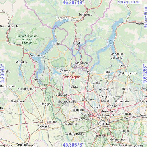
Concagno GPS coordinates[2]
45° 47' 56.904" North, 8° 54' 34.416" East
| Map corner | latitude | longitude |
|---|---|---|
| Upper-left | 46.28719°, | 8.20643° |
| Center: | 45.79914°, | 8.90956° |
| Lower-right: | 45.30678°, | 9.61268° |
| Map W x H: | 109×109 km | = 67.7×67.7mi |
| max Lat: | 47.04031° ⇑14.3% North |
| Concagno: | 45.79914° |
| min Lat: | ⇓85.7% South 35.50142° |
| min Long | Concagno | max Long |
| 6.69888° | 8.90956° | 18.48682° |
| W 17.4%⇐ | ⇒82.6% E |
Elevation
Elevation of Concagno is 396 m = 1299 ft, and this is 89.3 m = 293 ft above average elevation for this country.
| Max E: |
2085 m = 6841 ft | 29.8% |
| Concagno | 396 m 1299 ft | |
| Avg. | 306.7 m = 1006 ft | |
Min E: |
-4 m = -13 ft | 70.2% |
See also: Italy elevation on elevation.city.
Geographical zone
Concagno is located in North temperate zone (between Tropic of Cancer and the Arctic Circle). Distance of this North polar circle is 2308.8 km =1434.6 mi to North.| Distance of | km | miles | from Concagno |
|---|---|---|---|
| North Pole | 4914.7 | 3053.9 | to North |
| Arctic Circle | 2308.8 | 1434.6 | to North |
| Tropic Cancer | 2486.5 | 1545 | to South |
| Equator | 5092.4 | 3164.3 | to South |


Nearby cities:
15 places around Concagno: (largest is in red/bold)
• Albiolo
2.4 km =1.5 mi,  72°
72°
• Beregazzo con Figliaro
3.4 km =2.1 mi,  127°
127°
• Binago
2.1 km =1.3 mi,  152°
152°
• Bizzarone
4.7 km =2.9 mi,  33°
33°
• Cagno
1.5 km =0.9 mi,  24°
24°
• Cantello
2.8 km =1.7 mi,  337°
337°
• Faloppio
4.4 km =2.7 mi, 74°
• Figliaro
3.5 km =2.2 mi, 128°
• Gaggino
4.4 km =2.7 mi,  77°
77°
• Gaggiolo
4.3 km =2.7 mi,  0°
0°
• Malnate
2.3 km =1.4 mi,  254°
254°
• Rodero
2.8 km =1.7 mi,  9°
9°
• Solbiate
2.1 km =1.3 mi,  119°
119°
• Valmorea
2.4 km =1.5 mi,  42°
42°
• Vedano Olona
3.1 km =1.9 mi,  213°
213°
Sources, notices
• [Note1] Compared only with cities in Italy existing in our database
• [Src1] Map data: © OpenStreetMap contributors (CC-BY-SA)
• [Src2] Other city data from geonames.org with taken over terms of usage.
• [Src3] Geographical zone / Annual Mean Temperature by Robert A. Rohde @ Wikipedia
