Magnago geodata
Magnago (Lombardy) is a seat of a third-order administrative division; located in Italy in Europe/Rome (GMT+2) time zone. With population of 8,726 people, there are 1092 cities with bigger population in this country. Compared to other cities in Italy, 76.2% of cities are located further ↓South; 84.1% of cities are located further →East and 55.3% of cities have higher elevation than Magnago. Note1
Administrative division(s):
- Level 1: Lombardy
- Level 2: Città metropolitana di Milano
- Level 3: Magnago


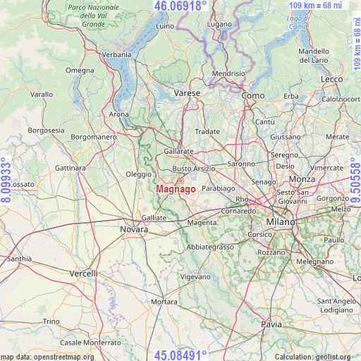
Magnago GPS coordinates[2]
45° 34' 45.12" North, 8° 48' 8.82" East
| Map corner | latitude | longitude |
|---|---|---|
| Upper-left | 46.06918°, | 8.09933° |
| Center: | 45.5792°, | 8.80245° |
| Lower-right: | 45.08491°, | 9.50558° |
| Map W x H: | 109.4×109.4 km | = 68×68mi |
| max Lat: | 47.04031° ⇑23.8% North |
| Magnago: | 45.5792° |
| min Lat: | ⇓76.2% South 35.50142° |
| min Long | Magnago | max Long |
| 6.69888° | 8.80245° | 18.48682° |
| W 15.9%⇐ | ⇒84.1% E |
Elevation
Elevation of Magnago is 200 m = 656 ft, and this is 106.7 m = 350 ft below average elevation for this country.
| Max E: |
2085 m = 6841 ft | 55.3% |
| Avg. | 306.7 m = 1006 ft | |
| Magnago | 200 m = 656 ft | |
Min E: |
-4 m = -13 ft | 44.7% |
See also: Italy elevation on elevation.city.
Geographical zone
Magnago is located in North temperate zone (between Tropic of Cancer and the Arctic Circle). Distance of this North polar circle is 2333.2 km =1449.8 mi to North.| Distance of | km | miles | from Magnago |
|---|---|---|---|
| North Pole | 4939.1 | 3069 | to North |
| Arctic Circle | 2333.2 | 1449.8 | to North |
| Tropic Cancer | 2462 | 1529.8 | to South |
| Equator | 5067.9 | 3149 | to South |


Nearby cities:
15 places around Magnago: (largest is in red/bold)
• Arconate
5.6 km =3.5 mi,  139°
139°
• Buscate
4 km =2.5 mi,  168°
168°
• Busto Arsizio
5.1 km =3.2 mi,  45°
45°
• Cascina Elisa
2.8 km =1.7 mi,  355°
355°
• Castano Primo
3.7 km =2.3 mi,  214°
214°
• Dairago
4.9 km =3 mi,  107°
107°
• Ferno
5.3 km =3.3 mi,  318°
318°
• Lonate Pozzolo
4.2 km =2.6 mi,  290°
290°
• Nosate
6.8 km =4.2 mi,  242°
242°
• Robecchetto Con Induno
6.2 km =3.9 mi,  203°
203°
• Samarate
5.2 km =3.2 mi,  344°
344°
• San Macario
4 km =2.5 mi,  326°
326°
• Tornavento
6.8 km =4.2 mi,  273°
273°
• Vanzaghello
1.6 km =1 mi, 271°
• Villa Cortese
6.7 km =4.2 mi,  101°
101°
Sources, notices
• [Note1] Compared only with cities in Italy existing in our database
• [Src1] Map data: © OpenStreetMap contributors (CC-BY-SA)
• [Src2] Other city data from geonames.org with taken over terms of usage.
• [Src3] Geographical zone / Annual Mean Temperature by Robert A. Rohde @ Wikipedia
