Nosate geodata
Nosate (Lombardy) is a seat of a third-order administrative division; located in Italy in Europe/Rome (GMT+2) time zone. With population of 647 people, there are 8651 cities with bigger population in this country. Compared to other cities in Italy, 75.3% of cities are located further ↓South; 85.2% of cities are located further →East and 58.5% of cities have higher elevation than Nosate. Note1
Administrative division(s):
- Level 1: Lombardy
- Level 2: Città metropolitana di Milano
- Level 3: Nosate


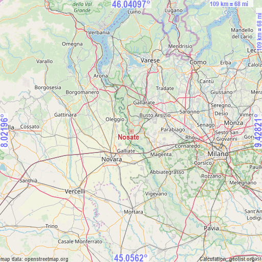
Nosate GPS coordinates[2]
45° 33' 2.664" North, 8° 43' 30.324" East
| Map corner | latitude | longitude |
|---|---|---|
| Upper-left | 46.04097°, | 8.02196° |
| Center: | 45.55074°, | 8.72509° |
| Lower-right: | 45.0562°, | 9.42821° |
| Map W x H: | 109.5×109.5 km | = 68×68mi |
| max Lat: | 47.04031° ⇑24.7% North |
| Nosate: | 45.55074° |
| min Lat: | ⇓75.3% South 35.50142° |
| min Long | Nosate | max Long |
| 6.69888° | 8.72509° | 18.48682° |
| W 14.8%⇐ | ⇒85.2% E |
Elevation
Elevation of Nosate is 175 m = 574 ft, and this is 131.7 m = 432 ft below average elevation for this country.
| Max E: |
2085 m = 6841 ft | 58.5% |
| Avg. | 306.7 m = 1006 ft | |
| Nosate | 175 m = 574 ft | |
Min E: |
-4 m = -13 ft | 41.5% |
See also: Italy elevation on elevation.city.
Geographical zone
Nosate is located in North temperate zone (between Tropic of Cancer and the Arctic Circle). Distance of this North polar circle is 2336.4 km =1451.8 mi to North.| Distance of | km | miles | from Nosate |
|---|---|---|---|
| North Pole | 4942.3 | 3071 | to North |
| Arctic Circle | 2336.4 | 1451.8 | to North |
| Tropic Cancer | 2458.8 | 1527.8 | to South |
| Equator | 5064.8 | 3147.1 | to South |


Nearby cities:
15 places around Nosate: (largest is in red/bold)
• Bellinzago Novarese
6.7 km =4.2 mi,  287°
287°
• Buscate
6.9 km =4.3 mi,  96°
96°
• Cameri
7.3 km =4.5 mi,  221°
221°
• Cascina Elisa
8.3 km =5.2 mi,  44°
44°
• Castano Primo
3.9 km =2.4 mi,  88°
88°
• Ferno
7.6 km =4.7 mi,  19°
19°
• Galliate
8.2 km =5.1 mi,  194°
194°
• Lonate Pozzolo
5.1 km =3.2 mi, 24°
• Magnago
6.8 km =4.2 mi,  62°
62°
• Oleggio
8.2 km =5.1 mi,  308°
308°
• Robecchetto Con Induno
4.3 km =2.7 mi,  124°
124°
• San Macario
7.5 km =4.7 mi,  30°
30°
• Tornavento
3.7 km =2.3 mi,  347°
347°
• Turbigo
2.4 km =1.5 mi,  157°
157°
• Vanzaghello
5.5 km =3.4 mi,  54°
54°
Sources, notices
• [Note1] Compared only with cities in Italy existing in our database
• [Src1] Map data: © OpenStreetMap contributors (CC-BY-SA)
• [Src2] Other city data from geonames.org with taken over terms of usage.
• [Src3] Geographical zone / Annual Mean Temperature by Robert A. Rohde @ Wikipedia
