Buscate geodata
Buscate (Lombardy) is a seat of a third-order administrative division; located in Italy in Europe/Rome (GMT+2) time zone. With population of 4,656 people, there are 2087 cities with bigger population in this country. Compared to other cities in Italy, 75.1% of cities are located further ↓South; 84% of cities are located further →East and 58.1% of cities have higher elevation than Buscate. Note1
Administrative division(s):
- Level 1: Lombardy
- Level 2: Città metropolitana di Milano
- Level 3: Buscate


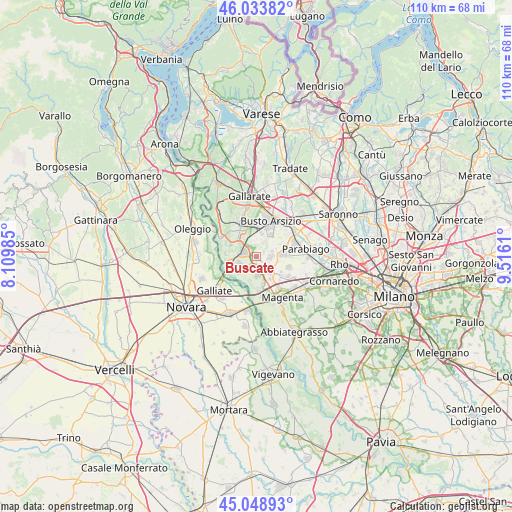
Buscate GPS coordinates[2]
45° 32' 36.708" North, 8° 48' 46.692" East
| Map corner | latitude | longitude |
|---|---|---|
| Upper-left | 46.03382°, | 8.10985° |
| Center: | 45.54353°, | 8.81297° |
| Lower-right: | 45.04893°, | 9.5161° |
| Map W x H: | 109.5×109.5 km | = 68×68mi |
| max Lat: | 47.04031° ⇑24.9% North |
| Buscate: | 45.54353° |
| min Lat: | ⇓75.1% South 35.50142° |
| min Long | Buscate | max Long |
| 6.69888° | 8.81297° | 18.48682° |
| W 16%⇐ | ⇒84% E |
Elevation
Elevation of Buscate is 179 m = 587 ft, and this is 127.7 m = 419 ft below average elevation for this country.
| Max E: |
2085 m = 6841 ft | 58.1% |
| Avg. | 306.7 m = 1006 ft | |
| Buscate | 179 m = 587 ft | |
Min E: |
-4 m = -13 ft | 41.9% |
See also: Italy elevation on elevation.city.
Geographical zone
Buscate is located in North temperate zone (between Tropic of Cancer and the Arctic Circle). Distance of this North polar circle is 2337.2 km =1452.3 mi to North.| Distance of | km | miles | from Buscate |
|---|---|---|---|
| North Pole | 4943.1 | 3071.5 | to North |
| Arctic Circle | 2337.2 | 1452.3 | to North |
| Tropic Cancer | 2458 | 1527.3 | to South |
| Equator | 5064 | 3146.6 | to South |


Nearby cities:
15 places around Buscate: (largest is in red/bold)
• Arconate
2.8 km =1.7 mi,  94°
94°
• Busto Garolfo
5.5 km =3.4 mi,  84°
84°
• Casate
5.8 km =3.6 mi,  168°
168°
• Cascina Elisa
6.8 km =4.2 mi,  351°
351°
• Castano Primo
3 km =1.9 mi,  287°
287°
• Cuggiono
4.1 km =2.5 mi,  177°
177°
• Dairago
4.6 km =2.9 mi,  57°
57°
• Furato
6.2 km =3.9 mi,  121°
121°
• Inveruno
4.3 km =2.7 mi,  139°
139°
• Magnago
4 km =2.5 mi, 348°
• Mesero
5.7 km =3.5 mi, 144°
• Robecchetto Con Induno
3.7 km =2.3 mi,  243°
243°
• Turbigo
6.1 km =3.8 mi,  256°
256°
• Vanzaghello
4.7 km =2.9 mi,  329°
329°
• Villa Cortese
6.3 km =3.9 mi,  65°
65°
Sources, notices
• [Note1] Compared only with cities in Italy existing in our database
• [Src1] Map data: © OpenStreetMap contributors (CC-BY-SA)
• [Src2] Other city data from geonames.org with taken over terms of usage.
• [Src3] Geographical zone / Annual Mean Temperature by Robert A. Rohde @ Wikipedia
