Mafalda geodata
Mafalda (Molise) is a seat of a third-order administrative division; located in Italy in Europe/Rome (GMT+2) time zone. With population of 981 people, there are 6736 cities with bigger population in this country. Compared to other cities in Italy, 70.9% of cities are located further ↑North; 84.6% of cities are located further ←West and 74.4% of cities have lower elevation than Mafalda. Note1


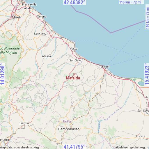
Mafalda GPS coordinates[2]
41° 56' 35.088" North, 14° 42' 57.96" East
| Map corner | latitude | longitude |
|---|---|---|
| Upper-left | 42.46392°, | 14.01298° |
| Center: | 41.94308°, | 14.7161° |
| Lower-right: | 41.41795°, | 15.41923° |
| Map W x H: | 116.3×116.3 km | = 72.3×72.3mi |
| max Lat: | 47.04031° ⇑70.9% North |
| Mafalda: | 41.94308° |
| min Lat: | ⇓29.1% South 35.50142° |
| min Long | Mafalda | max Long |
| 6.69888° | 14.7161° | 18.48682° |
| W 84.6%⇐ | ⇒15.4% E |
Elevation
Elevation of Mafalda is 444 m = 1457 ft, and this is 137.3 m = 450 ft above average elevation for this country.
| Max E: |
2085 m = 6841 ft | 25.6% |
| Mafalda | 444 m 1457 ft | |
| Avg. | 306.7 m = 1006 ft | |
Min E: |
-4 m = -13 ft | 74.4% |
See also: Italy elevation on elevation.city.
Geographical zone
Mafalda is located in North temperate zone (between Tropic of Cancer and the Arctic Circle). Distance of this Northern Tropic circle is 2057.7 km =1278.6 mi to South.| Distance of | km | miles | from Mafalda |
|---|---|---|---|
| North Pole | 5343.4 | 3320.2 | to North |
| Arctic Circle | 2737.5 | 1701 | to North |
| Tropic Cancer | 2057.7 | 1278.6 | to South |
| Equator | 4663.6 | 2897.8 | to South |


Nearby cities:
15 places around Mafalda: (largest is in red/bold)
• Acquaviva Collecroce
8.9 km =5.5 mi,  163°
163°
• Castelmauro
12.8 km =8 mi,  182°
182°
• Dogliola
6.7 km =4.2 mi,  269°
269°
• Fresagrandinaria
6 km =3.7 mi,  311°
311°
• Lentella
6.7 km =4.2 mi,  331°
331°
• Montecilfone
11 km =6.8 mi,  114°
114°
• Montefalcone nel Sannio
10.7 km =6.6 mi,  217°
217°
• Montemitro
8.4 km =5.2 mi, 223°
• Montenero di Bisaccia
5.9 km =3.7 mi,  66°
66°
• Palata
8.5 km =5.3 mi,  135°
135°
• Palmoli
11.1 km =6.9 mi, 267°
• San Felice del Molise
6 km =3.7 mi,  192°
192°
• San Salvo
11.3 km =7 mi,  7°
7°
• Tavenna
5.4 km =3.4 mi, 135°
• Tufillo
8 km =5 mi,  248°
248°
Sources, notices
• [Note1] Compared only with cities in Italy existing in our database
• [Src1] Map data: © OpenStreetMap contributors (CC-BY-SA)
• [Src2] Other city data from geonames.org with taken over terms of usage.
• [Src3] Geographical zone / Annual Mean Temperature by Robert A. Rohde @ Wikipedia
