Lustra geodata
Lustra (Campania) is a seat of a third-order administrative division; located in Italy in Europe/Rome (GMT+2) time zone. With population of 268 people, there are 10809 cities with bigger population in this country. Compared to other cities in Italy, 85.7% of cities are located further ↑North; 87.7% of cities are located further ←West and 76.3% of cities have lower elevation than Lustra. Note1


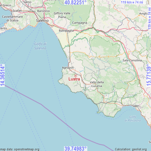
Lustra GPS coordinates[2]
40° 17' 17.88" North, 15° 4' 5.736" East
| Map corner | latitude | longitude |
|---|---|---|
| Upper-left | 40.82251°, | 14.36514° |
| Center: | 40.2883°, | 15.06826° |
| Lower-right: | 39.74983°, | 15.77139° |
| Map W x H: | 119.3×119.3 km | = 74.1×74.1mi |
| max Lat: | 47.04031° ⇑85.7% North |
| Lustra: | 40.2883° |
| min Lat: | ⇓14.3% South 35.50142° |
| min Long | Lustra | max Long |
| 6.69888° | 15.06826° | 18.48682° |
| W 87.7%⇐ | ⇒12.3% E |
Elevation
Elevation of Lustra is 469 m = 1539 ft, and this is 162.3 m = 532 ft above average elevation for this country.
| Max E: |
2085 m = 6841 ft | 23.7% |
| Lustra | 469 m 1539 ft | |
| Avg. | 306.7 m = 1006 ft | |
Min E: |
-4 m = -13 ft | 76.3% |
See also: Italy elevation on elevation.city.
Geographical zone
Lustra is located in North temperate zone (between Tropic of Cancer and the Arctic Circle). Distance of this Northern Tropic circle is 1873.7 km =1164.3 mi to South.| Distance of | km | miles | from Lustra |
|---|---|---|---|
| North Pole | 5527.4 | 3434.6 | to North |
| Arctic Circle | 2921.5 | 1815.3 | to North |
| Tropic Cancer | 1873.7 | 1164.3 | to South |
| Equator | 4479.6 | 2783.5 | to South |


Nearby cities:
15 places around Lustra: (largest is in red/bold)
• Copersito
3 km =1.9 mi,  350°
350°
• Fasana
7.3 km =4.5 mi,  125°
125°
• Laureana Cilento
2.9 km =1.8 mi,  299°
299°
• Ogliastro Cilento
7.2 km =4.5 mi, 345°
• Omignano
4.5 km =2.8 mi,  162°
162°
• Omignano Scalo
7 km =4.3 mi, 127°
• Perdifumo
5 km =3.1 mi,  241°
241°
• Perito
6.8 km =4.2 mi,  80°
80°
• Prignano Cilento
5 km =3.1 mi,  359°
359°
• Rutino
1.4 km =0.9 mi,  17°
17°
• San Mauro Cilento
7.2 km =4.5 mi,  196°
196°
• Serramezzana
5.7 km =3.5 mi,  212°
212°
• Sessa Cilento
3.3 km =2.1 mi,  168°
168°
• Stella Cilento
6.6 km =4.1 mi, 161°
• Torchiara
3.9 km =2.4 mi,  341°
341°
Sources, notices
• [Note1] Compared only with cities in Italy existing in our database
• [Src1] Map data: © OpenStreetMap contributors (CC-BY-SA)
• [Src2] Other city data from geonames.org with taken over terms of usage.
• [Src3] Geographical zone / Annual Mean Temperature by Robert A. Rohde @ Wikipedia
