Torchiara geodata
Torchiara (Campania) is a seat of a third-order administrative division; located in Italy in Europe/Rome (GMT+2) time zone. With population of 516 people, there are 9765 cities with bigger population in this country. Compared to other cities in Italy, 85.4% of cities are located further ↑North; 87.6% of cities are located further ←West and 65.2% of cities have lower elevation than Torchiara. Note1


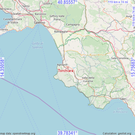
Torchiara GPS coordinates[2]
40° 19' 17.832" North, 15° 3' 13.32" East
| Map corner | latitude | longitude |
|---|---|---|
| Upper-left | 40.85557°, | 14.35058° |
| Center: | 40.32162°, | 15.0537° |
| Lower-right: | 39.78341°, | 15.75683° |
| Map W x H: | 119.2×119.2 km | = 74.1×74.1mi |
| max Lat: | 47.04031° ⇑85.4% North |
| Torchiara: | 40.32162° |
| min Lat: | ⇓14.6% South 35.50142° |
| min Long | Torchiara | max Long |
| 6.69888° | 15.0537° | 18.48682° |
| W 87.6%⇐ | ⇒12.4% E |
Elevation
Elevation of Torchiara is 345 m = 1132 ft, and this is 38.3 m = 126 ft above average elevation for this country.
| Max E: |
2085 m = 6841 ft | 34.8% |
| Torchiara | 345 m 1132 ft | |
| Avg. | 306.7 m = 1006 ft | |
Min E: |
-4 m = -13 ft | 65.2% |
See also: Italy elevation on elevation.city.
Geographical zone
Torchiara is located in North temperate zone (between Tropic of Cancer and the Arctic Circle). Distance of this Northern Tropic circle is 1877.4 km =1166.6 mi to South.| Distance of | km | miles | from Torchiara |
|---|---|---|---|
| North Pole | 5523.7 | 3432.3 | to North |
| Arctic Circle | 2917.8 | 1813 | to North |
| Tropic Cancer | 1877.4 | 1166.6 | to South |
| Equator | 4483.3 | 2785.8 | to South |


Nearby cities:
15 places around Torchiara: (largest is in red/bold)
• Agropoli
6.2 km =3.9 mi,  299°
299°
• Alano
7.2 km =4.5 mi,  255°
255°
• Cicerale
6.9 km =4.3 mi,  68°
68°
• Copersito
1.1 km =0.7 mi,  135°
135°
• Laureana Cilento
2.6 km =1.6 mi,  209°
209°
• Lustra
3.9 km =2.4 mi,  161°
161°
• Mattine
7.5 km =4.7 mi,  341°
341°
• Ogliastro Cilento
3.3 km =2.1 mi,  349°
349°
• Omignano
8.4 km =5.2 mi, 162°
• Perdifumo
6.8 km =4.2 mi, 207°
• Perito
8.4 km =5.2 mi,  107°
107°
• Prignano Cilento
1.7 km =1.1 mi,  41°
41°
• Rutino
2.9 km =1.8 mi, 144°
• Serramezzana
8.8 km =5.5 mi,  191°
191°
• Sessa Cilento
7.2 km =4.5 mi, 164°
Sources, notices
• [Note1] Compared only with cities in Italy existing in our database
• [Src1] Map data: © OpenStreetMap contributors (CC-BY-SA)
• [Src2] Other city data from geonames.org with taken over terms of usage.
• [Src3] Geographical zone / Annual Mean Temperature by Robert A. Rohde @ Wikipedia
