Luogosano geodata
Luogosano (Campania) is a seat of a third-order administrative division; located in Italy in Europe/Rome (GMT+2) time zone. With population of 1,118 people, there are 6220 cities with bigger population in this country. Compared to other cities in Italy, 78.8% of cities are located further ↑North; 87.1% of cities are located further ←West and 71.5% of cities have lower elevation than Luogosano. Note1


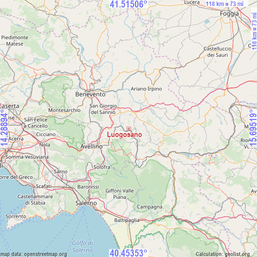
Luogosano GPS coordinates[2]
40° 59' 11.148" North, 14° 59' 31.416" East
| Map corner | latitude | longitude |
|---|---|---|
| Upper-left | 41.51506°, | 14.28894° |
| Center: | 40.98643°, | 14.99206° |
| Lower-right: | 40.45353°, | 15.69519° |
| Map W x H: | 118×118 km | = 73.3×73.3mi |
| max Lat: | 47.04031° ⇑78.8% North |
| Luogosano: | 40.98643° |
| min Lat: | ⇓21.2% South 35.50142° |
| min Long | Luogosano | max Long |
| 6.69888° | 14.99206° | 18.48682° |
| W 87.1%⇐ | ⇒12.9% E |
Elevation
Elevation of Luogosano is 410 m = 1345 ft, and this is 103.3 m = 339 ft above average elevation for this country.
| Max E: |
2085 m = 6841 ft | 28.5% |
| Luogosano | 410 m 1345 ft | |
| Avg. | 306.7 m = 1006 ft | |
Min E: |
-4 m = -13 ft | 71.5% |
See also: Italy elevation on elevation.city.
Geographical zone
Luogosano is located in North temperate zone (between Tropic of Cancer and the Arctic Circle). Distance of this Northern Tropic circle is 1951.3 km =1212.5 mi to South.| Distance of | km | miles | from Luogosano |
|---|---|---|---|
| North Pole | 5449.8 | 3386.3 | to North |
| Arctic Circle | 2843.9 | 1767.1 | to North |
| Tropic Cancer | 1951.3 | 1212.5 | to South |
| Equator | 4557.3 | 2831.8 | to South |


Nearby cities:
15 places around Luogosano: (largest is in red/bold)
• Castelfranci
7.5 km =4.7 mi,  145°
145°
• Castelvetere sul Calore
6.3 km =3.9 mi,  184°
184°
• Fontanarosa
4.3 km =2.7 mi,  34°
34°
• Gesualdo
7.1 km =4.4 mi,  72°
72°
• Lapio
3.8 km =2.4 mi,  264°
264°
• Mirabella Eclano
6.5 km =4 mi,  6°
6°
• Montemarano
8.1 km =5 mi, 176°
• Montemiletto
8.2 km =5.1 mi,  290°
290°
• Passo di Mirabella-Pianopantano
7.9 km =4.9 mi,  15°
15°
• Paternopoli
3.7 km =2.3 mi,  114°
114°
• San Mango sul Calore
3.5 km =2.2 mi,  208°
208°
• Sant'Angelo All'Esca
2.2 km =1.4 mi,  2°
2°
• Taurasi
3.8 km =2.4 mi,  315°
315°
• Torre le Nocelle
8.1 km =5 mi,  300°
300°
• Villamaina
8.3 km =5.2 mi,  101°
101°
Sources, notices
• [Note1] Compared only with cities in Italy existing in our database
• [Src1] Map data: © OpenStreetMap contributors (CC-BY-SA)
• [Src2] Other city data from geonames.org with taken over terms of usage.
• [Src3] Geographical zone / Annual Mean Temperature by Robert A. Rohde @ Wikipedia
