Stallavena-Lugo geodata
Stallavena-Lugo (Veneto) is a populated place; located in Italy in Europe/Rome (GMT+2) time zone. With population of 2,936 people, there are 3095 cities with bigger population in this country. Compared to other cities in Italy, 75.6% of cities are located further ↓South; 57.4% of cities are located further →East and 57.1% of cities have lower elevation than Stallavena-Lugo. Note1


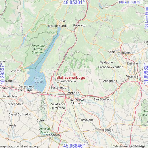
Stallavena-Lugo GPS coordinates[2]
45° 33' 46.404" North, 10° 59' 48.084" East
| Map corner | latitude | longitude |
|---|---|---|
| Upper-left | 46.05301°, | 10.29357° |
| Center: | 45.56289°, | 10.99669° |
| Lower-right: | 45.06846°, | 11.69982° |
| Map W x H: | 109.5×109.5 km | = 68×68mi |
| max Lat: | 47.04031° ⇑24.4% North |
| Stallavena-Lugo: | 45.56289° |
| min Lat: | ⇓75.6% South 35.50142° |
| min Long | Stallavena-Lugo | max Long |
| 6.69888° | 10.99669° | 18.48682° |
| W 42.6%⇐ | ⇒57.4% E |
Elevation
Elevation of Stallavena-Lugo is 279 m = 915 ft, and this is 27.7 m = 91 ft below average elevation for this country.
| Max E: |
2085 m = 6841 ft | 42.9% |
| Avg. | 306.7 m = 1006 ft | |
| Stallavena-Lugo | 279 m = 915 ft | |
Min E: |
-4 m = -13 ft | 57.1% |
See also: Italy elevation on elevation.city.
Geographical zone
Stallavena-Lugo is located in North temperate zone (between Tropic of Cancer and the Arctic Circle). Distance of this North polar circle is 2335.1 km =1451 mi to North.| Distance of | km | miles | from Stallavena-Lugo |
|---|---|---|---|
| North Pole | 4940.9 | 3070.1 | to North |
| Arctic Circle | 2335.1 | 1451 | to North |
| Tropic Cancer | 2460.2 | 1528.7 | to South |
| Equator | 5066.1 | 3147.9 | to South |


Nearby cities:
15 places around Stallavena-Lugo: (largest is in red/bold)
• Bosco Chiesanuova
7 km =4.3 mi,  23°
23°
• Cerro Veronese
3.7 km =2.3 mi,  69°
69°
• Corbiolo
4.9 km =3 mi,  32°
32°
• Erbezzo
8.5 km =5.3 mi,  2°
2°
• Fane
3.1 km =1.9 mi,  305°
305°
• Grezzana
4.7 km =2.9 mi,  160°
160°
• Marano di Valpolicella
6.3 km =3.9 mi,  263°
263°
• Montericco
8.5 km =5.3 mi,  201°
201°
• Negrar
5.9 km =3.7 mi,  230°
230°
• Roverè Veronese
6.6 km =4.1 mi,  59°
59°
• San Floriano
8.5 km =5.3 mi, 234°
• San Rocco
7.1 km =4.4 mi,  99°
99°
• Sant'Anna d'Alfaedo
8 km =5 mi,  333°
333°
• Santa Maria In Stelle
8.3 km =5.2 mi, 158°
• Valgatara
7.3 km =4.5 mi,  244°
244°
Sources, notices
• [Note1] Compared only with cities in Italy existing in our database
• [Src1] Map data: © OpenStreetMap contributors (CC-BY-SA)
• [Src2] Other city data from geonames.org with taken over terms of usage.
• [Src3] Geographical zone / Annual Mean Temperature by Robert A. Rohde @ Wikipedia
