Loreo geodata
Loreo (Veneto) is a seat of a third-order administrative division; located in Italy in Europe/Rome (GMT+2) time zone. With population of 2,497 people, there are 3523 cities with bigger population in this country. Compared to other cities in Italy, 61.5% of cities are located further ↓South; 58.5% of cities are located further ←West and 99.4% of cities have higher elevation than Loreo. Note1


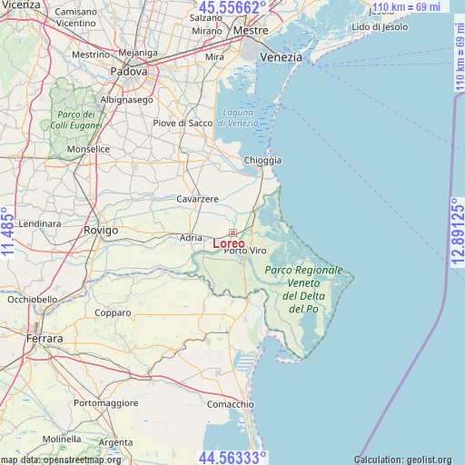
Loreo GPS coordinates[2]
45° 3' 43.668" North, 12° 11' 17.232" East
| Map corner | latitude | longitude |
|---|---|---|
| Upper-left | 45.55662°, | 11.485° |
| Center: | 45.06213°, | 12.18812° |
| Lower-right: | 44.56333°, | 12.89125° |
| Map W x H: | 110.4×110.4 km | = 68.6×68.6mi |
| max Lat: | 47.04031° ⇑38.5% North |
| Loreo: | 45.06213° |
| min Lat: | ⇓61.5% South 35.50142° |
| min Long | Loreo | max Long |
| 6.69888° | 12.18812° | 18.48682° |
| W 58.5%⇐ | ⇒41.5% E |
Elevation
Elevation of Loreo is 1 m = 3 ft, and this is 305.7 m = 1003 ft below average elevation for this country.
| Max E: |
2085 m = 6841 ft | 99.4% |
| Avg. | 306.7 m = 1006 ft | |
| Loreo | 1 m = 3 ft | |
Min E: |
-4 m = -13 ft | 0.6% |
See also: Italy elevation on elevation.city.
Geographical zone
Loreo is located in North temperate zone (between Tropic of Cancer and the Arctic Circle). Distance of this North polar circle is 2390.7 km =1485.5 mi to North.| Distance of | km | miles | from Loreo |
|---|---|---|---|
| North Pole | 4996.6 | 3104.7 | to North |
| Arctic Circle | 2390.7 | 1485.5 | to North |
| Tropic Cancer | 2404.5 | 1494.1 | to South |
| Equator | 5010.4 | 3113.3 | to South |


Nearby cities:
15 places around Loreo: (largest is in red/bold)
• Adria
10.4 km =6.5 mi,  265°
265°
• Ariano
13.8 km =8.6 mi,  201°
201°
• Boscochiaro
9.8 km =6.1 mi,  327°
327°
• Bottrighe
9.3 km =5.8 mi,  243°
243°
• Ca' Lino
14 km =8.7 mi,  38°
38°
• Cavarzere
11.5 km =7.1 mi,  314°
314°
• Corbola
10.4 km =6.5 mi,  230°
230°
• Papozze
8.9 km =5.5 mi,  190°
190°
• Porto Viro
4.6 km =2.9 mi,  149°
149°
• Rosolina
3.7 km =2.3 mi,  63°
63°
• Sant'Anna
13.4 km =8.3 mi,  30°
30°
• Taglio
4.8 km =3 mi,  158°
158°
• Taglio di Po
7 km =4.3 mi, 163°
• Valliera
13.6 km =8.5 mi, 269°
• Villaggio Busonera
11.8 km =7.3 mi,  322°
322°
Sources, notices
• [Note1] Compared only with cities in Italy existing in our database
• [Src1] Map data: © OpenStreetMap contributors (CC-BY-SA)
• [Src2] Other city data from geonames.org with taken over terms of usage.
• [Src3] Geographical zone / Annual Mean Temperature by Robert A. Rohde @ Wikipedia
