Cavarzere geodata
Cavarzere (Veneto) is a seat of a third-order administrative division; located in Italy in Europe/Rome (GMT+2) time zone. With population of 8,992 people, there are 1058 cities with bigger population in this country. Compared to other cities in Italy, 63.3% of cities are located further ↓South; 57.1% of cities are located further ←West and 97.8% of cities have higher elevation than Cavarzere. Note1


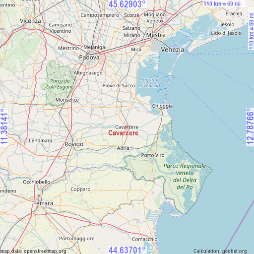
Cavarzere GPS coordinates[2]
45° 8' 6.648" North, 12° 5' 4.308" East
| Map corner | latitude | longitude |
|---|---|---|
| Upper-left | 45.62903°, | 11.38141° |
| Center: | 45.13518°, | 12.08453° |
| Lower-right: | 44.63701°, | 12.78766° |
| Map W x H: | 110.3×110.3 km | = 68.5×68.5mi |
| max Lat: | 47.04031° ⇑36.7% North |
| Cavarzere: | 45.13518° |
| min Lat: | ⇓63.3% South 35.50142° |
| min Long | Cavarzere | max Long |
| 6.69888° | 12.08453° | 18.48682° |
| W 57.1%⇐ | ⇒42.9% E |
Elevation
Elevation of Cavarzere is 4 m = 13 ft, and this is 302.7 m = 993 ft below average elevation for this country.
| Max E: |
2085 m = 6841 ft | 97.8% |
| Avg. | 306.7 m = 1006 ft | |
| Cavarzere | 4 m = 13 ft | |
Min E: |
-4 m = -13 ft | 2.2% |
See also: Italy elevation on elevation.city.
Geographical zone
Cavarzere is located in North temperate zone (between Tropic of Cancer and the Arctic Circle). Distance of this North polar circle is 2382.6 km =1480.5 mi to North.| Distance of | km | miles | from Cavarzere |
|---|---|---|---|
| North Pole | 4988.5 | 3099.7 | to North |
| Arctic Circle | 2382.6 | 1480.5 | to North |
| Tropic Cancer | 2412.6 | 1499.1 | to South |
| Equator | 5018.6 | 3118.4 | to South |


Nearby cities:
15 places around Cavarzere: (largest is in red/bold)
• Adria
9.3 km =5.8 mi,  194°
194°
• Agna
10.8 km =6.7 mi,  291°
291°
• Baricetta
11 km =6.8 mi,  218°
218°
• Beverare
10.9 km =6.8 mi,  268°
268°
• Boscochiaro
2.9 km =1.8 mi,  86°
86°
• Candiana
12 km =7.5 mi,  323°
323°
• Civé
9.6 km =6 mi,  32°
32°
• Correzzola
11.2 km =7 mi,  353°
353°
• Loreo
11.5 km =7.1 mi,  134°
134°
• Pegolotte
7.3 km =4.5 mi,  329°
329°
• Pettorazza Grimani
7.6 km =4.7 mi, 270°
• Rottanova
5.3 km =3.3 mi,  280°
280°
• Valliera
9.9 km =6.2 mi,  213°
213°
• Villa del Bosco
9.9 km =6.2 mi, 334°
• Villaggio Busonera
1.6 km =1 mi,  36°
36°
Sources, notices
• [Note1] Compared only with cities in Italy existing in our database
• [Src1] Map data: © OpenStreetMap contributors (CC-BY-SA)
• [Src2] Other city data from geonames.org with taken over terms of usage.
• [Src3] Geographical zone / Annual Mean Temperature by Robert A. Rohde @ Wikipedia
