Valliera geodata
Valliera (Veneto) is a populated place; located in Italy in Europe/Rome (GMT+2) time zone. With population of 719 people, there are 8161 cities with bigger population in this country. Compared to other cities in Italy, 61.4% of cities are located further ↓South; 56.1% of cities are located further ←West and 99.4% of cities have higher elevation than Valliera. Note1


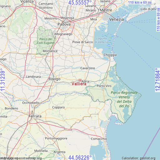
Valliera GPS coordinates[2]
45° 3' 39.852" North, 12° 0' 55.836" East
| Map corner | latitude | longitude |
|---|---|---|
| Upper-left | 45.55557°, | 11.31239° |
| Center: | 45.06107°, | 12.01551° |
| Lower-right: | 44.56226°, | 12.71864° |
| Map W x H: | 110.4×110.4 km | = 68.6×68.6mi |
| max Lat: | 47.04031° ⇑38.6% North |
| Valliera: | 45.06107° |
| min Lat: | ⇓61.4% South 35.50142° |
| min Long | Valliera | max Long |
| 6.69888° | 12.01551° | 18.48682° |
| W 56.1%⇐ | ⇒43.9% E |
Elevation
Elevation of Valliera is 1 m = 3 ft, and this is 305.7 m = 1003 ft below average elevation for this country.
| Max E: |
2085 m = 6841 ft | 99.4% |
| Avg. | 306.7 m = 1006 ft | |
| Valliera | 1 m = 3 ft | |
Min E: |
-4 m = -13 ft | 0.6% |
See also: Italy elevation on elevation.city.
Geographical zone
Valliera is located in North temperate zone (between Tropic of Cancer and the Arctic Circle). Distance of this North polar circle is 2390.9 km =1485.6 mi to North.| Distance of | km | miles | from Valliera |
|---|---|---|---|
| North Pole | 4996.7 | 3104.8 | to North |
| Arctic Circle | 2390.9 | 1485.6 | to North |
| Tropic Cancer | 2404.4 | 1494 | to South |
| Equator | 5010.3 | 3113.3 | to South |


Nearby cities:
15 places around Valliera: (largest is in red/bold)
• Adria
3.3 km =2.1 mi,  103°
103°
• Baricetta
1.4 km =0.9 mi,  255°
255°
• Berra
9.9 km =6.2 mi,  197°
197°
• Beverare
9.7 km =6 mi,  325°
325°
• Bottrighe
6.6 km =4.1 mi,  126°
126°
• Braglia
8.6 km =5.3 mi,  170°
170°
• Cavarzere
9.9 km =6.2 mi,  33°
33°
• Corbola
8.5 km =5.3 mi,  139°
139°
• Gavello
9 km =5.6 mi,  243°
243°
• Lama Pezzoli
8.6 km =5.3 mi, 256°
• Papozze
8.5 km =5.3 mi, 171°
• Pettorazza Grimani
8.6 km =5.3 mi,  345°
345°
• Rottanova
9.2 km =5.7 mi,  1°
1°
• Villadose
9.2 km =5.7 mi,  277°
277°
• Villanova Marchesana
8.6 km =5.3 mi,  206°
206°
Sources, notices
• [Note1] Compared only with cities in Italy existing in our database
• [Src1] Map data: © OpenStreetMap contributors (CC-BY-SA)
• [Src2] Other city data from geonames.org with taken over terms of usage.
• [Src3] Geographical zone / Annual Mean Temperature by Robert A. Rohde @ Wikipedia
