Ovodda geodata
Ovodda (Sardinia) is a seat of a third-order administrative division; located in Italy in Europe/Rome (GMT+2) time zone. With population of 1,627 people, there are 4827 cities with bigger population in this country. Compared to other cities in Italy, 87.2% of cities are located further ↑North; 78.7% of cities are located further →East and 90% of cities have lower elevation than Ovodda. Note1


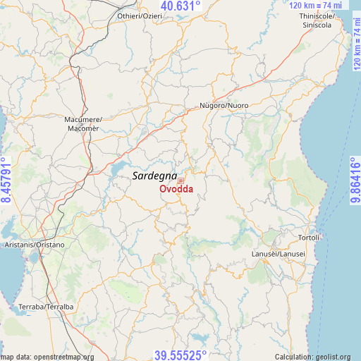
Ovodda GPS coordinates[2]
40° 5' 42.9" North, 9° 9' 39.708" East
| Map corner | latitude | longitude |
|---|---|---|
| Upper-left | 40.631°, | 8.45791° |
| Center: | 40.09525°, | 9.16103° |
| Lower-right: | 39.55525°, | 9.86416° |
| Map W x H: | 119.6×119.6 km | = 74.3×74.3mi |
| max Lat: | 47.04031° ⇑87.2% North |
| Ovodda: | 40.09525° |
| min Lat: | ⇓12.8% South 35.50142° |
| min Long | Ovodda | max Long |
| 6.69888° | 9.16103° | 18.48682° |
| W 21.3%⇐ | ⇒78.7% E |
Elevation
Elevation of Ovodda is 720 m = 2362 ft, and this is 413.3 m = 1356 ft above average elevation for this country.
| Max E: |
2085 m = 6841 ft | 10% |
| Ovodda | 720 m 2362 ft | |
| Avg. | 306.7 m = 1006 ft | |
Min E: |
-4 m = -13 ft | 90% |
See also: Italy elevation on elevation.city.
Geographical zone
Ovodda is located in North temperate zone (between Tropic of Cancer and the Arctic Circle). Distance of this Northern Tropic circle is 1852.3 km =1151 mi to South.| Distance of | km | miles | from Ovodda |
|---|---|---|---|
| North Pole | 5548.9 | 3447.9 | to North |
| Arctic Circle | 2943 | 1828.7 | to North |
| Tropic Cancer | 1852.3 | 1151 | to South |
| Equator | 4458.2 | 2770.2 | to South |


Nearby cities:
15 places around Ovodda: (largest is in red/bold)
• Aritzo
15.4 km =9.6 mi,  169°
169°
• Atzara
13.5 km =8.4 mi,  212°
212°
• Austis
6.7 km =4.2 mi,  246°
246°
• Belvì
15 km =9.3 mi, 172°
• Desulo
10.7 km =6.6 mi,  146°
146°
• Fonni
8.3 km =5.2 mi,  71°
71°
• Gavoi
7.9 km =4.9 mi,  21°
21°
• Lodine
7.8 km =4.8 mi,  39°
39°
• Ollolai
8.2 km =5.1 mi,  9°
9°
• Olzai
9.8 km =6.1 mi,  352°
352°
• Sarule
14.8 km =9.2 mi,  1°
1°
• Sorgono
9.2 km =5.7 mi, 213°
• Teti
3.6 km =2.2 mi,  273°
273°
• Tiana
3.3 km =2.1 mi,  199°
199°
• Tonara
7.9 km =4.9 mi, 173°
Sources, notices
• [Note1] Compared only with cities in Italy existing in our database
• [Src1] Map data: © OpenStreetMap contributors (CC-BY-SA)
• [Src2] Other city data from geonames.org with taken over terms of usage.
• [Src3] Geographical zone / Annual Mean Temperature by Robert A. Rohde @ Wikipedia
