Tiana geodata
Tiana (Sardinia) is a seat of a third-order administrative division; located in Italy in Europe/Rome (GMT+2) time zone. With population of 521 people, there are 9723 cities with bigger population in this country. Compared to other cities in Italy, 87.4% of cities are located further ↑North; 78.9% of cities are located further →East and 82.3% of cities have lower elevation than Tiana. Note1


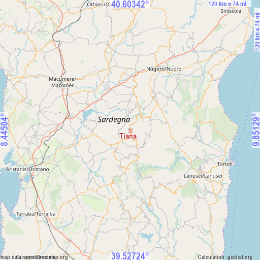
Tiana GPS coordinates[2]
40° 4' 2.856" North, 9° 8' 53.412" East
| Map corner | latitude | longitude |
|---|---|---|
| Upper-left | 40.60342°, | 8.44504° |
| Center: | 40.06746°, | 9.14817° |
| Lower-right: | 39.52724°, | 9.85129° |
| Map W x H: | 119.7×119.7 km | = 74.4×74.4mi |
| max Lat: | 47.04031° ⇑87.4% North |
| Tiana: | 40.06746° |
| min Lat: | ⇓12.6% South 35.50142° |
| min Long | Tiana | max Long |
| 6.69888° | 9.14817° | 18.48682° |
| W 21.1%⇐ | ⇒78.9% E |
Elevation
Elevation of Tiana is 561 m = 1841 ft, and this is 254.3 m = 834 ft above average elevation for this country.
| Max E: |
2085 m = 6841 ft | 17.7% |
| Tiana | 561 m 1841 ft | |
| Avg. | 306.7 m = 1006 ft | |
Min E: |
-4 m = -13 ft | 82.3% |
See also: Italy elevation on elevation.city.
Geographical zone
Tiana is located in North temperate zone (between Tropic of Cancer and the Arctic Circle). Distance of this Northern Tropic circle is 1849.2 km =1149 mi to South.| Distance of | km | miles | from Tiana |
|---|---|---|---|
| North Pole | 5552 | 3449.9 | to North |
| Arctic Circle | 2946.1 | 1830.6 | to North |
| Tropic Cancer | 1849.2 | 1149 | to South |
| Equator | 4455.1 | 2768.3 | to South |


Nearby cities:
15 places around Tiana: (largest is in red/bold)
• Aritzo
12.6 km =7.8 mi,  162°
162°
• Atzara
10.3 km =6.4 mi,  216°
216°
• Austis
5.1 km =3.2 mi,  274°
274°
• Belvì
12.1 km =7.5 mi,  165°
165°
• Desulo
9.2 km =5.7 mi,  129°
129°
• Fonni
10.7 km =6.6 mi,  57°
57°
• Gavoi
11.2 km =7 mi,  20°
20°
• Lodine
10.9 km =6.8 mi,  33°
33°
• Ollolai
11.5 km =7.1 mi,  12°
12°
• Olzai
12.8 km =8 mi,  359°
359°
• Ortueri
14.3 km =8.9 mi,  255°
255°
• Ovodda
3.3 km =2.1 mi, 19°
• Sorgono
6.1 km =3.8 mi, 220°
• Teti
4.1 km =2.5 mi,  323°
323°
• Tonara
5.2 km =3.2 mi, 156°
Sources, notices
• [Note1] Compared only with cities in Italy existing in our database
• [Src1] Map data: © OpenStreetMap contributors (CC-BY-SA)
• [Src2] Other city data from geonames.org with taken over terms of usage.
• [Src3] Geographical zone / Annual Mean Temperature by Robert A. Rohde @ Wikipedia
