Lodi geodata
Lodi (Lombardy) is a seat of a second-order administrative division; located in Italy in Europe/Rome (GMT+2) time zone. With population of 40,767 people, there are 175 cities with bigger population in this country. Compared to other cities in Italy, 67.7% of cities are located further ↓South; 73.2% of cities are located further →East and 73% of cities have higher elevation than Lodi. Note1


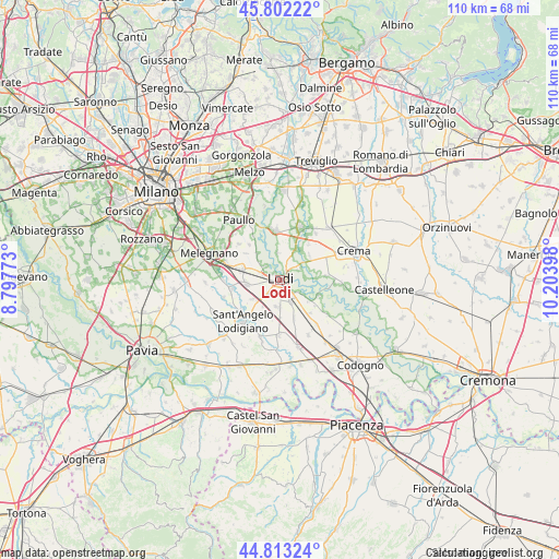
Lodi GPS coordinates[2]
45° 18' 35.604" North, 9° 30' 3.06" East
| Map corner | latitude | longitude |
|---|---|---|
| Upper-left | 45.80222°, | 8.79773° |
| Center: | 45.30989°, | 9.50085° |
| Lower-right: | 44.81324°, | 10.20398° |
| Map W x H: | 110×110 km | = 68.4×68.4mi |
| max Lat: | 47.04031° ⇑32.3% North |
| Lodi: | 45.30989° |
| min Lat: | ⇓67.7% South 35.50142° |
| min Long | Lodi | max Long |
| 6.69888° | 9.50085° | 18.48682° |
| W 26.8%⇐ | ⇒73.2% E |
Elevation
Elevation of Lodi is 83 m = 272 ft, and this is 223.7 m = 734 ft below average elevation for this country.
| Max E: |
2085 m = 6841 ft | 73% |
| Avg. | 306.7 m = 1006 ft | |
| Lodi | 83 m = 272 ft | |
Min E: |
-4 m = -13 ft | 27% |
See also: Lodi elevation on elevation.city.
Geographical zone
Lodi is located in North temperate zone (between Tropic of Cancer and the Arctic Circle). Distance of this North polar circle is 2363.2 km =1468.4 mi to North.| Distance of | km | miles | from Lodi |
|---|---|---|---|
| North Pole | 4969.1 | 3087.7 | to North |
| Arctic Circle | 2363.2 | 1468.4 | to North |
| Tropic Cancer | 2432.1 | 1511.2 | to South |
| Equator | 5038 | 3130.5 | to South |


Nearby cities:
15 places around Lodi: (largest is in red/bold)
• Abbadia Cerreto
7.3 km =4.5 mi,  88°
88°
• Boffalora d'Adda
5.4 km =3.4 mi,  356°
356°
• Borgo San Giovanni
6.3 km =3.9 mi,  235°
235°
• Cadilana
4.1 km =2.5 mi,  56°
56°
• Crespiatica
7.5 km =4.7 mi,  52°
52°
• Dovera
6.9 km =4.3 mi,  29°
29°
• Galgagnano
6.9 km =4.3 mi,  320°
320°
• Lodi Vecchio
6.5 km =4 mi,  264°
264°
• Massalengo-Motta Vigana
5.1 km =3.2 mi,  189°
189°
• Montanaso Lombardo
3.9 km =2.4 mi, 315°
• Muzza di Cornegliano Laudense
3.6 km =2.2 mi,  219°
219°
• Pieve Fissiraga
6.2 km =3.9 mi,  212°
212°
• San Martino in Strada
4.4 km =2.7 mi,  152°
152°
• Tavazzano
7.8 km =4.8 mi,  284°
284°
• Terraverde-Corte Palasio
4.8 km =3 mi,  82°
82°
Sources, notices
• [Note1] Compared only with cities in Italy existing in our database
• [Src1] Map data: © OpenStreetMap contributors (CC-BY-SA)
• [Src2] Other city data from geonames.org with taken over terms of usage.
• [Src3] Geographical zone / Annual Mean Temperature by Robert A. Rohde @ Wikipedia
