Dovera geodata
Dovera (Lombardy) is a seat of a third-order administrative division; located in Italy in Europe/Rome (GMT+2) time zone. With population of 3,659 people, there are 2579 cities with bigger population in this country. Compared to other cities in Italy, 69.3% of cities are located further ↓South; 72.7% of cities are located further →East and 75.2% of cities have higher elevation than Dovera. Note1


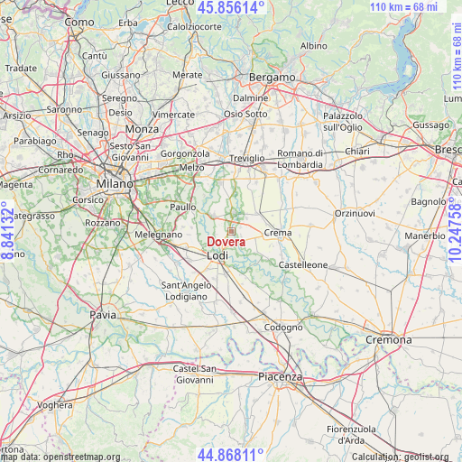
Dovera GPS coordinates[2]
45° 21' 51.408" North, 9° 32' 40.02" East
| Map corner | latitude | longitude |
|---|---|---|
| Upper-left | 45.85614°, | 8.84132° |
| Center: | 45.36428°, | 9.54445° |
| Lower-right: | 44.86811°, | 10.24758° |
| Map W x H: | 109.9×109.9 km | = 68.3×68.3mi |
| max Lat: | 47.04031° ⇑30.7% North |
| Dovera: | 45.36428° |
| min Lat: | ⇓69.3% South 35.50142° |
| min Long | Dovera | max Long |
| 6.69888° | 9.54445° | 18.48682° |
| W 27.3%⇐ | ⇒72.7% E |
Elevation
Elevation of Dovera is 73 m = 240 ft, and this is 233.7 m = 767 ft below average elevation for this country.
| Max E: |
2085 m = 6841 ft | 75.2% |
| Avg. | 306.7 m = 1006 ft | |
| Dovera | 73 m = 240 ft | |
Min E: |
-4 m = -13 ft | 24.8% |
See also: Italy elevation on elevation.city.
Geographical zone
Dovera is located in North temperate zone (between Tropic of Cancer and the Arctic Circle). Distance of this North polar circle is 2357.1 km =1464.6 mi to North.| Distance of | km | miles | from Dovera |
|---|---|---|---|
| North Pole | 4963 | 3083.9 | to North |
| Arctic Circle | 2357.1 | 1464.6 | to North |
| Tropic Cancer | 2438.1 | 1515 | to South |
| Equator | 5044 | 3134.2 | to South |


Nearby cities:
15 places around Dovera: (largest is in red/bold)
• Abbadia Cerreto
7 km =4.3 mi,  146°
146°
• Bagnolo Cremasco
5.4 km =3.4 mi,  93°
93°
• Boffalora d'Adda
3.8 km =2.4 mi,  260°
260°
• Cadilana
3.8 km =2.4 mi,  179°
179°
• Chieve
6.2 km =3.9 mi,  115°
115°
• Crespiatica
2.9 km =1.8 mi, 119°
• Lodi
6.9 km =4.3 mi,  209°
209°
• Monte Cremasco
2.4 km =1.5 mi,  68°
68°
• Nosadello
4.4 km =2.7 mi,  345°
345°
• Palazzo Pignano
3.5 km =2.2 mi,  34°
34°
• Pandino
4.6 km =2.9 mi,  7°
7°
• Scannabue-Cascine Capri
5 km =3.1 mi,  49°
49°
• Spino d'Adda
6.1 km =3.8 mi,  312°
312°
• Terraverde-Corte Palasio
5.6 km =3.5 mi,  166°
166°
• Vaiano Cremasco
3.5 km =2.2 mi,  77°
77°
Sources, notices
• [Note1] Compared only with cities in Italy existing in our database
• [Src1] Map data: © OpenStreetMap contributors (CC-BY-SA)
• [Src2] Other city data from geonames.org with taken over terms of usage.
• [Src3] Geographical zone / Annual Mean Temperature by Robert A. Rohde @ Wikipedia
