Cadilana geodata
Cadilana (Lombardy) is a populated place; located in Italy in Europe/Rome (GMT+2) time zone. With population of 659 people, there are 8563 cities with bigger population in this country. Compared to other cities in Italy, 68.3% of cities are located further ↓South; 72.7% of cities are located further →East and 76.3% of cities have higher elevation than Cadilana. Note1


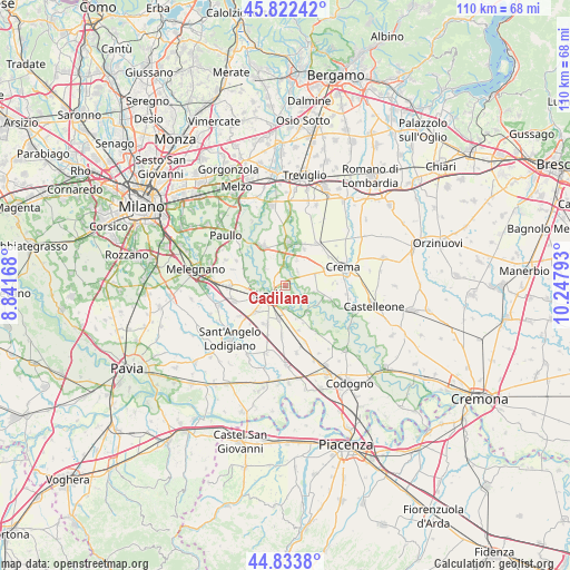
Cadilana GPS coordinates[2]
45° 19' 48.972" North, 9° 32' 41.28" East
| Map corner | latitude | longitude |
|---|---|---|
| Upper-left | 45.82242°, | 8.84168° |
| Center: | 45.33027°, | 9.5448° |
| Lower-right: | 44.8338°, | 10.24793° |
| Map W x H: | 109.9×109.9 km | = 68.3×68.3mi |
| max Lat: | 47.04031° ⇑31.7% North |
| Cadilana: | 45.33027° |
| min Lat: | ⇓68.3% South 35.50142° |
| min Long | Cadilana | max Long |
| 6.69888° | 9.5448° | 18.48682° |
| W 27.3%⇐ | ⇒72.7% E |
Elevation
Elevation of Cadilana is 68 m = 223 ft, and this is 238.7 m = 783 ft below average elevation for this country.
| Max E: |
2085 m = 6841 ft | 76.3% |
| Avg. | 306.7 m = 1006 ft | |
| Cadilana | 68 m = 223 ft | |
Min E: |
-4 m = -13 ft | 23.7% |
See also: Italy elevation on elevation.city.
Geographical zone
Cadilana is located in North temperate zone (between Tropic of Cancer and the Arctic Circle). Distance of this North polar circle is 2360.9 km =1467 mi to North.| Distance of | km | miles | from Cadilana |
|---|---|---|---|
| North Pole | 4966.8 | 3086.2 | to North |
| Arctic Circle | 2360.9 | 1467 | to North |
| Tropic Cancer | 2434.3 | 1512.6 | to South |
| Equator | 5040.3 | 3131.9 | to South |


Nearby cities:
15 places around Cadilana: (largest is in red/bold)
• Abbadia Cerreto
4.4 km =2.7 mi,  117°
117°
• Bagnolo Cremasco
6.3 km =3.9 mi,  57°
57°
• Boffalora d'Adda
4.9 km =3 mi,  309°
309°
• Casaletto Ceredano
5.8 km =3.6 mi,  103°
103°
• Cavenago d'Adda
6.8 km =4.2 mi,  141°
141°
• Chieve
5.7 km =3.5 mi,  78°
78°
• Crespiatica
3.4 km =2.1 mi,  46°
46°
• Dovera
3.8 km =2.4 mi,  359°
359°
• Lodi
4.1 km =2.5 mi,  236°
236°
• Montanaso Lombardo
6.2 km =3.9 mi,  275°
275°
• Monte Cremasco
5.2 km =3.2 mi,  25°
25°
• Palazzo Pignano
6.9 km =4.3 mi,  16°
16°
• San Martino in Strada
6.3 km =3.9 mi,  193°
193°
• Terraverde-Corte Palasio
2.1 km =1.3 mi, 141°
• Vaiano Cremasco
5.7 km =3.5 mi,  36°
36°
Sources, notices
• [Note1] Compared only with cities in Italy existing in our database
• [Src1] Map data: © OpenStreetMap contributors (CC-BY-SA)
• [Src2] Other city data from geonames.org with taken over terms of usage.
• [Src3] Geographical zone / Annual Mean Temperature by Robert A. Rohde @ Wikipedia
