Locorotondo geodata
Locorotondo (Apulia) is a seat of a third-order administrative division; located in Italy in Europe/Rome (GMT+2) time zone. With population of 7,471 people, there are 1302 cities with bigger population in this country. Compared to other cities in Italy, 81.8% of cities are located further ↑North; 98.4% of cities are located further ←West and 69% of cities have lower elevation than Locorotondo. Note1


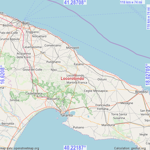
Locorotondo GPS coordinates[2]
40° 45' 23.796" North, 17° 19' 26.112" East
| Map corner | latitude | longitude |
|---|---|---|
| Upper-left | 41.28708°, | 16.6208° |
| Center: | 40.75661°, | 17.32392° |
| Lower-right: | 40.22187°, | 18.02705° |
| Map W x H: | 118.4×118.4 km | = 73.6×73.6mi |
| max Lat: | 47.04031° ⇑81.8% North |
| Locorotondo: | 40.75661° |
| min Lat: | ⇓18.2% South 35.50142° |
| min Long | Locorotondo | max Long |
| 6.69888° | 17.32392° | 18.48682° |
| W 98.4%⇐ | ⇒1.6% E |
Elevation
Elevation of Locorotondo is 384 m = 1260 ft, and this is 77.3 m = 254 ft above average elevation for this country.
| Max E: |
2085 m = 6841 ft | 31% |
| Locorotondo | 384 m 1260 ft | |
| Avg. | 306.7 m = 1006 ft | |
Min E: |
-4 m = -13 ft | 69% |
See also: Italy elevation on elevation.city.
Geographical zone
Locorotondo is located in North temperate zone (between Tropic of Cancer and the Arctic Circle). Distance of this Northern Tropic circle is 1925.8 km =1196.6 mi to South.| Distance of | km | miles | from Locorotondo |
|---|---|---|---|
| North Pole | 5475.4 | 3402.3 | to North |
| Arctic Circle | 2869.5 | 1783 | to North |
| Tropic Cancer | 1925.8 | 1196.6 | to South |
| Equator | 4531.7 | 2815.9 | to South |


Nearby cities:
15 places around Locorotondo: (largest is in red/bold)
• Alberobello
8 km =5 mi,  292°
292°
• Casalini
12.5 km =7.8 mi,  99°
99°
• Cisternino
8.7 km =5.4 mi, 99°
• Coreggia
7.5 km =4.7 mi,  317°
317°
• Fasano
9.4 km =5.8 mi,  18°
18°
• Impalata
13.2 km =8.2 mi,  344°
344°
• Lamie di Olimpie-Selva
6.8 km =4.2 mi,  7°
7°
• Madonna Pozzo Guacito
12.1 km =7.5 mi,  62°
62°
• Martina Franca
6 km =3.7 mi,  168°
168°
• Montalbano
13.5 km =8.4 mi,  79°
79°
• Pezze di Greco
9.6 km =6 mi,  51°
51°
• Sant'Antonio d'Ascula
14 km =8.7 mi, 5°
• Santa Lucia
10.3 km =6.4 mi, 344°
• Speziale
12 km =7.5 mi,  71°
71°
• Stazione di Fasano
11.1 km =6.9 mi,  25°
25°
Sources, notices
• [Note1] Compared only with cities in Italy existing in our database
• [Src1] Map data: © OpenStreetMap contributors (CC-BY-SA)
• [Src2] Other city data from geonames.org with taken over terms of usage.
• [Src3] Geographical zone / Annual Mean Temperature by Robert A. Rohde @ Wikipedia
