Alberobello geodata
Alberobello (Apulia) is a seat of a third-order administrative division; located in Italy in Europe/Rome (GMT+2) time zone. With population of 9,391 people, there are 1002 cities with bigger population in this country. Compared to other cities in Italy, 81.6% of cities are located further ↑North; 98.3% of cities are located further ←West and 72.2% of cities have lower elevation than Alberobello. Note1


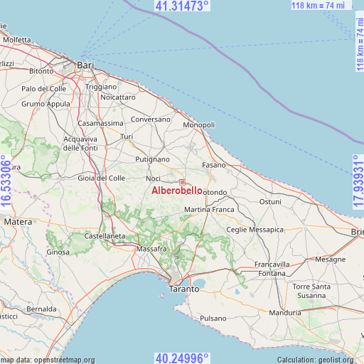
Alberobello GPS coordinates[2]
40° 47' 4.128" North, 17° 14' 10.248" East
| Map corner | latitude | longitude |
|---|---|---|
| Upper-left | 41.31473°, | 16.53306° |
| Center: | 40.78448°, | 17.23618° |
| Lower-right: | 40.24996°, | 17.93931° |
| Map W x H: | 118.4×118.4 km | = 73.6×73.6mi |
| max Lat: | 47.04031° ⇑81.6% North |
| Alberobello: | 40.78448° |
| min Lat: | ⇓18.4% South 35.50142° |
| min Long | Alberobello | max Long |
| 6.69888° | 17.23618° | 18.48682° |
| W 98.3%⇐ | ⇒1.7% E |
Elevation
Elevation of Alberobello is 417 m = 1368 ft, and this is 110.3 m = 362 ft above average elevation for this country.
| Max E: |
2085 m = 6841 ft | 27.8% |
| Alberobello | 417 m 1368 ft | |
| Avg. | 306.7 m = 1006 ft | |
Min E: |
-4 m = -13 ft | 72.2% |
See also: Italy elevation on elevation.city.
Geographical zone
Alberobello is located in North temperate zone (between Tropic of Cancer and the Arctic Circle). Distance of this Northern Tropic circle is 1928.9 km =1198.6 mi to South.| Distance of | km | miles | from Alberobello |
|---|---|---|---|
| North Pole | 5472.3 | 3400.3 | to North |
| Arctic Circle | 2866.4 | 1781.1 | to North |
| Tropic Cancer | 1928.9 | 1198.6 | to South |
| Equator | 4534.8 | 2817.8 | to South |


Nearby cities:
15 places around Alberobello: (largest is in red/bold)
• Alcanterini
11.1 km =6.9 mi,  334°
334°
• Antonelli
12.4 km =7.7 mi,  359°
359°
• Castellana
12.8 km =8 mi, 332°
• Coreggia
3.4 km =2.1 mi,  43°
43°
• Fasano
11.9 km =7.4 mi,  61°
61°
• Gorgofreddo
11.5 km =7.1 mi,  11°
11°
• Impalata
10.3 km =6.4 mi,  21°
21°
• Lamie di Olimpie-Selva
9.1 km =5.7 mi,  66°
66°
• Locorotondo
8 km =5 mi,  112°
112°
• Martina Franca
12.4 km =7.7 mi,  136°
136°
• Noci
9.3 km =5.8 mi,  276°
276°
• Putignano
12.1 km =7.5 mi,  307°
307°
• Sant'Antonio d'Ascula
13.8 km =8.6 mi, 38°
• Santa Lucia
8.2 km =5.1 mi,  34°
34°
• Stazione di Fasano
14.1 km =8.8 mi, 60°
Sources, notices
• [Note1] Compared only with cities in Italy existing in our database
• [Src1] Map data: © OpenStreetMap contributors (CC-BY-SA)
• [Src2] Other city data from geonames.org with taken over terms of usage.
• [Src3] Geographical zone / Annual Mean Temperature by Robert A. Rohde @ Wikipedia
