Olcenengo geodata
Olcenengo (Piedmont) is a seat of a third-order administrative division; located in Italy in Europe/Rome (GMT+1) time zone. With population of 701 people, there are 8293 cities with bigger population in this country. Compared to other cities in Italy, 69.2% of cities are located further ↓South; 90% of cities are located further →East and 62% of cities have higher elevation than Olcenengo. Note1


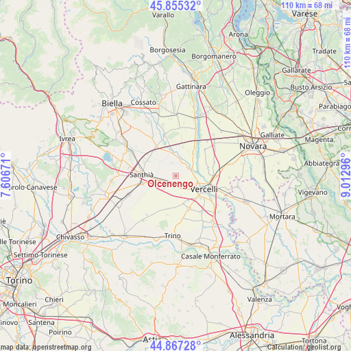
Olcenengo GPS coordinates[2]
45° 21' 48.456" North, 8° 18' 35.388" East
| Map corner | latitude | longitude |
|---|---|---|
| Upper-left | 45.85532°, | 7.60671° |
| Center: | 45.36346°, | 8.30983° |
| Lower-right: | 44.86728°, | 9.01296° |
| Map W x H: | 109.9×109.9 km | = 68.3×68.3mi |
| max Lat: | 47.04031° ⇑30.8% North |
| Olcenengo: | 45.36346° |
| min Lat: | ⇓69.2% South 35.50142° |
| min Long | Olcenengo | max Long |
| 6.69888° | 8.30983° | 18.48682° |
| W 10%⇐ | ⇒90% E |
Elevation
Elevation of Olcenengo is 149 m = 489 ft, and this is 157.7 m = 517 ft below average elevation for this country.
| Max E: |
2085 m = 6841 ft | 62% |
| Avg. | 306.7 m = 1006 ft | |
| Olcenengo | 149 m = 489 ft | |
Min E: |
-4 m = -13 ft | 38% |
See also: Italy elevation on elevation.city.
Geographical zone
Olcenengo is located in North temperate zone (between Tropic of Cancer and the Arctic Circle). Distance of this North polar circle is 2357.2 km =1464.7 mi to North.| Distance of | km | miles | from Olcenengo |
|---|---|---|---|
| North Pole | 4963.1 | 3083.9 | to North |
| Arctic Circle | 2357.2 | 1464.7 | to North |
| Tropic Cancer | 2438 | 1514.9 | to South |
| Equator | 5043.9 | 3134.1 | to South |


Nearby cities:
15 places around Olcenengo: (largest is in red/bold)
• Albano Vercellese
8.9 km =5.5 mi,  38°
38°
• Caresanablot
6.5 km =4 mi,  96°
96°
• Casanova Elvo
4.3 km =2.7 mi,  343°
343°
• Collobiano
4.7 km =2.9 mi, 38°
• Crova
8.6 km =5.3 mi,  244°
244°
• Formigliana
7.4 km =4.6 mi,  349°
349°
• Lignana
9 km =5.6 mi,  162°
162°
• Oldenico
7.1 km =4.4 mi,  51°
51°
• Quinto Vercellese
4.4 km =2.7 mi,  66°
66°
• Salasco
5.5 km =3.4 mi,  220°
220°
• Sali Vercellese
6.1 km =3.8 mi,  165°
165°
• San Germano Vercellese
5.1 km =3.2 mi,  254°
254°
• Vercelli
9.8 km =6.1 mi,  118°
118°
• Villarboit
8.5 km =5.3 mi,  14°
14°
• Villata
9.9 km =6.2 mi,  75°
75°
Sources, notices
• [Note1] Compared only with cities in Italy existing in our database
• [Src1] Map data: © OpenStreetMap contributors (CC-BY-SA)
• [Src2] Other city data from geonames.org with taken over terms of usage.
• [Src3] Geographical zone / Annual Mean Temperature by Robert A. Rohde @ Wikipedia
