Lido di Ostia geodata
Lido di Ostia (Latium) is a populated place; located in Italy in Europe/Rome (GMT+2) time zone. With population of 79,400 people, there are 54 cities with bigger population in this country. Compared to other cities in Italy, 72.6% of cities are located further ↑North; 59.5% of cities are located further ←West and 93% of cities have higher elevation than Lido di Ostia. Note1
Administrative division(s):
- Level 1: Latium
- Level 2: Città metropolitana di Roma Capitale
- Level 3: Roma Capitale
- Level 4: Municipio Roma X


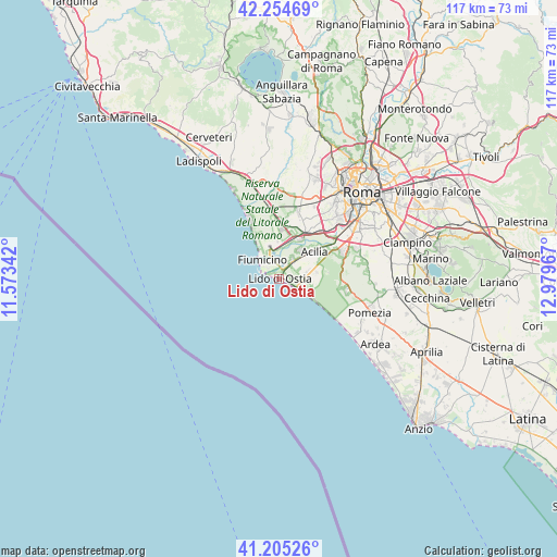
Lido di Ostia GPS coordinates[2]
41° 43' 55.632" North, 12° 16' 35.544" East
| Map corner | latitude | longitude |
|---|---|---|
| Upper-left | 42.25469°, | 11.57342° |
| Center: | 41.73212°, | 12.27654° |
| Lower-right: | 41.20526°, | 12.97967° |
| Map W x H: | 116.7×116.7 km | = 72.5×72.5mi |
| max Lat: | 47.04031° ⇑72.6% North |
| Lido di Ostia: | 41.73212° |
| min Lat: | ⇓27.4% South 35.50142° |
| min Long | Lido di Ostia | max Long |
| 6.69888° | 12.27654° | 18.48682° |
| W 59.5%⇐ | ⇒40.5% E |
Elevation
Elevation of Lido di Ostia is 12 m = 39 ft, and this is 294.7 m = 967 ft below average elevation for this country.
| Max E: |
2085 m = 6841 ft | 93% |
| Avg. | 306.7 m = 1006 ft | |
| Lido di Ostia | 12 m = 39 ft | |
Min E: |
-4 m = -13 ft | 7% |
See also: Lido di Ostia elevation on elevation.city.
Geographical zone
Lido di Ostia is located in North temperate zone (between Tropic of Cancer and the Arctic Circle). Distance of this Northern Tropic circle is 2034.3 km =1264.1 mi to South.| Distance of | km | miles | from Lido di Ostia |
|---|---|---|---|
| North Pole | 5366.9 | 3334.8 | to North |
| Arctic Circle | 2761 | 1715.6 | to North |
| Tropic Cancer | 2034.3 | 1264.1 | to South |
| Equator | 4640.2 | 2883.3 | to South |


Nearby cities:
15 places around Lido di Ostia: (largest is in red/bold)
• Acilia-Castel Fusano-Ostia Antica
5.7 km =3.5 mi,  52°
52°
• Casal Palocco
6.1 km =3.8 mi,  72°
72°
• Castel Fusano
3.4 km =2.1 mi,  60°
60°
• Colle del Pino
18.3 km =11.4 mi,  86°
86°
• Fiumicino-Isola Sacra
5.4 km =3.4 mi,  322°
322°
• Focene
10.5 km =6.5 mi,  330°
330°
• Fregene
14.7 km =9.1 mi, 333°
• La Massimina-Casal Lumbroso
17.1 km =10.6 mi,  22°
22°
• Maccarese
16.8 km =10.4 mi,  343°
343°
• Maccarese-Stazione
16.4 km =10.2 mi,  349°
349°
• Monte Migliore La Selvotta
18.8 km =11.7 mi, 93°
• Parco Leonardo
7.8 km =4.8 mi,  14°
14°
• Ponte Galeria-La Pisana
13.7 km =8.5 mi, 22°
• Selcetta
16.9 km =10.5 mi,  77°
77°
• Vitinia
12.7 km =7.9 mi, 58°
Sources, notices
• [Note1] Compared only with cities in Italy existing in our database
• [Src1] Map data: © OpenStreetMap contributors (CC-BY-SA)
• [Src2] Other city data from geonames.org with taken over terms of usage.
• [Src3] Geographical zone / Annual Mean Temperature by Robert A. Rohde @ Wikipedia
