Levanto geodata
Levanto (Liguria) is a seat of a third-order administrative division; located in Italy in Europe/Rome (GMT+2) time zone. With population of 4,135 people, there are 2321 cities with bigger population in this country. Compared to other cities in Italy, 53% of cities are located further ↑North; 71.7% of cities are located further →East and 92.6% of cities have higher elevation than Levanto. Note1


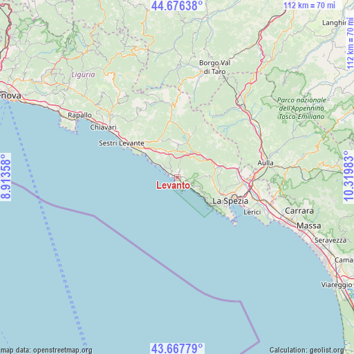
Levanto GPS coordinates[2]
44° 10' 27.264" North, 9° 37' 0.12" East
| Map corner | latitude | longitude |
|---|---|---|
| Upper-left | 44.67638°, | 8.91358° |
| Center: | 44.17424°, | 9.6167° |
| Lower-right: | 43.66779°, | 10.31983° |
| Map W x H: | 112.1×112.1 km | = 69.7×69.7mi |
| max Lat: | 47.04031° ⇑53% North |
| Levanto: | 44.17424° |
| min Lat: | ⇓47% South 35.50142° |
| min Long | Levanto | max Long |
| 6.69888° | 9.6167° | 18.48682° |
| W 28.3%⇐ | ⇒71.7% E |
Elevation
Elevation of Levanto is 13 m = 43 ft, and this is 293.7 m = 964 ft below average elevation for this country.
| Max E: |
2085 m = 6841 ft | 92.6% |
| Avg. | 306.7 m = 1006 ft | |
| Levanto | 13 m = 43 ft | |
Min E: |
-4 m = -13 ft | 7.4% |
See also: Italy elevation on elevation.city.
Geographical zone
Levanto is located in North temperate zone (between Tropic of Cancer and the Arctic Circle). Distance of this Northern Tropic circle is 2305.8 km =1432.8 mi to South.| Distance of | km | miles | from Levanto |
|---|---|---|---|
| North Pole | 5095.3 | 3166.1 | to North |
| Arctic Circle | 2489.5 | 1546.9 | to North |
| Tropic Cancer | 2305.8 | 1432.8 | to South |
| Equator | 4911.7 | 3052 | to South |


Nearby cities:
15 places around Levanto: (largest is in red/bold)
• Bonassola
2.8 km =1.7 mi,  291°
291°
• Borghetto di Vara
10 km =6.2 mi,  56°
56°
• Brugnato
11.1 km =6.9 mi,  51°
51°
• Carro
10.9 km =6.8 mi,  356°
356°
• Carrodano
8.1 km =5 mi,  22°
22°
• Deiva Marina
9.2 km =5.7 mi,  303°
303°
• Framura
6.4 km =4 mi,  308°
308°
• Moneglia
12.4 km =7.7 mi, 305°
• Monterosso al Mare
4.3 km =2.7 mi,  135°
135°
• Padivarma
12.3 km =7.6 mi,  78°
78°
• Pignone
8.5 km =5.3 mi,  87°
87°
• Riccò del Golfo
12 km =7.5 mi,  100°
100°
• Riomaggiore
12.8 km =8 mi,  130°
130°
• San Benedetto
13.6 km =8.5 mi,  109°
109°
• Vernazza
6.9 km =4.3 mi, 129°
Sources, notices
• [Note1] Compared only with cities in Italy existing in our database
• [Src1] Map data: © OpenStreetMap contributors (CC-BY-SA)
• [Src2] Other city data from geonames.org with taken over terms of usage.
• [Src3] Geographical zone / Annual Mean Temperature by Robert A. Rohde @ Wikipedia
