Lecce geodata
Lecce (Apulia) is a seat of a second-order administrative division; located in Italy in Europe/Rome (GMT+2) time zone. With population of 80,695 people, there are 50 cities with bigger population in this country. Compared to other cities in Italy, 85.2% of cities are located further ↑North; 99.3% of cities are located further ←West and 79.3% of cities have higher elevation than Lecce. Note1


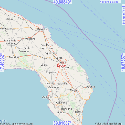
Lecce GPS coordinates[2]
40° 21' 17.316" North, 18° 10' 20.784" East
| Map corner | latitude | longitude |
|---|---|---|
| Upper-left | 40.88849°, | 17.46932° |
| Center: | 40.35481°, | 18.17244° |
| Lower-right: | 39.81687°, | 18.87557° |
| Map W x H: | 119.2×119.2 km | = 74.1×74.1mi |
| max Lat: | 47.04031° ⇑85.2% North |
| Lecce: | 40.35481° |
| min Lat: | ⇓14.8% South 35.50142° |
| min Long | Lecce | max Long |
| 6.69888° | 18.17244° | 18.48682° |
| W 99.3%⇐ | ⇒0.7% E |
Elevation
Elevation of Lecce is 53 m = 174 ft, and this is 253.7 m = 832 ft below average elevation for this country.
| Max E: |
2085 m = 6841 ft | 79.3% |
| Avg. | 306.7 m = 1006 ft | |
| Lecce | 53 m = 174 ft | |
Min E: |
-4 m = -13 ft | 20.7% |
See also: Lecce elevation on elevation.city.
Geographical zone
Lecce is located in North temperate zone (between Tropic of Cancer and the Arctic Circle). Distance of this Northern Tropic circle is 1881.1 km =1168.9 mi to South.| Distance of | km | miles | from Lecce |
|---|---|---|---|
| North Pole | 5520 | 3430 | to North |
| Arctic Circle | 2914.1 | 1810.7 | to North |
| Tropic Cancer | 1881.1 | 1168.9 | to South |
| Equator | 4487 | 2788.1 | to South |


Nearby cities:
15 places around Lecce: (largest is in red/bold)
• Aria Sana
2.9 km =1.8 mi,  190°
190°
• Arnesano
7.1 km =4.4 mi,  253°
253°
• Castromediano
3 km =1.9 mi,  169°
169°
• Cavallino
5.6 km =3.5 mi,  153°
153°
• Complesso Agave
2.8 km =1.7 mi,  100°
100°
• Giorgilorio
4.1 km =2.5 mi,  330°
330°
• Lequile
6.1 km =3.8 mi,  206°
206°
• Lizzanello
7 km =4.3 mi,  142°
142°
• Masseria Seminario
3.4 km =2.1 mi,  358°
358°
• Merine
4.9 km =3 mi,  117°
117°
• Monteroni di Lecce
7.9 km =4.9 mi,  240°
240°
• Riesci
6.8 km =4.2 mi,  261°
261°
• San Cesario di Lecce
5.9 km =3.7 mi, 189°
• San Pietro in Lama
6.5 km =4 mi,  215°
215°
• Surbo
5.4 km =3.4 mi,  323°
323°
Sources, notices
• [Note1] Compared only with cities in Italy existing in our database
• [Src1] Map data: © OpenStreetMap contributors (CC-BY-SA)
• [Src2] Other city data from geonames.org with taken over terms of usage.
• [Src3] Geographical zone / Annual Mean Temperature by Robert A. Rohde @ Wikipedia
