Merine geodata
Merine (Apulia) is a populated place; located in Italy in Europe/Rome (GMT+2) time zone. With population of 4,785 people, there are 2042 cities with bigger population in this country. Compared to other cities in Italy, 85.3% of cities are located further ↑North; 99.4% of cities are located further ←West and 82% of cities have higher elevation than Merine. Note1


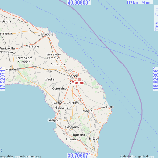
Merine GPS coordinates[2]
40° 20' 3.048" North, 18° 13' 25.788" East
| Map corner | latitude | longitude |
|---|---|---|
| Upper-left | 40.86803°, | 17.52071° |
| Center: | 40.33418°, | 18.22383° |
| Lower-right: | 39.79607°, | 18.92696° |
| Map W x H: | 119.2×119.2 km | = 74.1×74.1mi |
| max Lat: | 47.04031° ⇑85.3% North |
| Merine: | 40.33418° |
| min Lat: | ⇓14.7% South 35.50142° |
| min Long | Merine | max Long |
| 6.69888° | 18.22383° | 18.48682° |
| W 99.4%⇐ | ⇒0.59999999999999% E |
Elevation
Elevation of Merine is 42 m = 138 ft, and this is 264.7 m = 868 ft below average elevation for this country.
| Max E: |
2085 m = 6841 ft | 82% |
| Avg. | 306.7 m = 1006 ft | |
| Merine | 42 m = 138 ft | |
Min E: |
-4 m = -13 ft | 18% |
See also: Italy elevation on elevation.city.
Geographical zone
Merine is located in North temperate zone (between Tropic of Cancer and the Arctic Circle). Distance of this Northern Tropic circle is 1878.8 km =1167.4 mi to South.| Distance of | km | miles | from Merine |
|---|---|---|---|
| North Pole | 5522.3 | 3431.4 | to North |
| Arctic Circle | 2916.4 | 1812.2 | to North |
| Tropic Cancer | 1878.8 | 1167.4 | to South |
| Equator | 4484.7 | 2786.7 | to South |


Nearby cities:
15 places around Merine: (largest is in red/bold)
• Acquarica
8.4 km =5.2 mi,  111°
111°
• Aria Sana
4.9 km =3 mi,  263°
263°
• Castri di Lecce
7.5 km =4.7 mi,  154°
154°
• Castromediano
3.9 km =2.4 mi, 259°
• Cavallino
3.2 km =2 mi,  214°
214°
• Complesso Agave
2.4 km =1.5 mi,  318°
318°
• Lecce
4.9 km =3 mi,  297°
297°
• Lequile
7.8 km =4.8 mi,  246°
246°
• Lizzanello
3.3 km =2.1 mi,  181°
181°
• Masseria Seminario
7.2 km =4.5 mi, 321°
• Pisignano
5.2 km =3.2 mi,  129°
129°
• San Cesario di Lecce
6.4 km =4 mi,  236°
236°
• San Donato di Lecce
8.2 km =5.1 mi, 205°
• Strudà
5.2 km =3.2 mi, 107°
• Vernole
8.3 km =5.2 mi, 127°
Sources, notices
• [Note1] Compared only with cities in Italy existing in our database
• [Src1] Map data: © OpenStreetMap contributors (CC-BY-SA)
• [Src2] Other city data from geonames.org with taken over terms of usage.
• [Src3] Geographical zone / Annual Mean Temperature by Robert A. Rohde @ Wikipedia
