Lendinara geodata
Lendinara (Veneto) is a seat of a third-order administrative division; located in Italy in Europe/Rome (GMT+2) time zone. With population of 7,475 people, there are 1301 cities with bigger population in this country. Compared to other cities in Italy, 62% of cities are located further ↓South; 50.6% of cities are located further ←West and 94.8% of cities have higher elevation than Lendinara. Note1


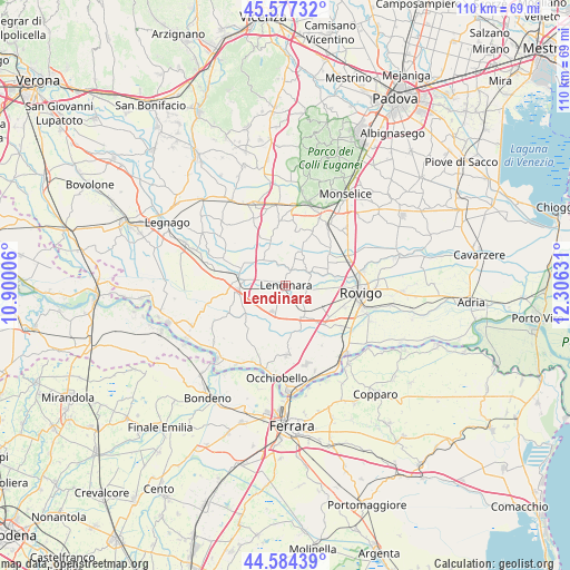
Lendinara GPS coordinates[2]
45° 4' 58.836" North, 11° 36' 11.448" East
| Map corner | latitude | longitude |
|---|---|---|
| Upper-left | 45.57732°, | 10.90006° |
| Center: | 45.08301°, | 11.60318° |
| Lower-right: | 44.58439°, | 12.30631° |
| Map W x H: | 110.4×110.4 km | = 68.6×68.6mi |
| max Lat: | 47.04031° ⇑38% North |
| Lendinara: | 45.08301° |
| min Lat: | ⇓62% South 35.50142° |
| min Long | Lendinara | max Long |
| 6.69888° | 11.60318° | 18.48682° |
| W 50.6%⇐ | ⇒49.4% E |
Elevation
Elevation of Lendinara is 9 m = 30 ft, and this is 297.7 m = 977 ft below average elevation for this country.
| Max E: |
2085 m = 6841 ft | 94.8% |
| Avg. | 306.7 m = 1006 ft | |
| Lendinara | 9 m = 30 ft | |
Min E: |
-4 m = -13 ft | 5.2% |
See also: Italy elevation on elevation.city.
Geographical zone
Lendinara is located in North temperate zone (between Tropic of Cancer and the Arctic Circle). Distance of this North polar circle is 2388.4 km =1484.1 mi to North.| Distance of | km | miles | from Lendinara |
|---|---|---|---|
| North Pole | 4994.3 | 3103.3 | to North |
| Arctic Circle | 2388.4 | 1484.1 | to North |
| Tropic Cancer | 2406.8 | 1495.5 | to South |
| Equator | 5012.8 | 3114.8 | to South |


Nearby cities:
15 places around Lendinara: (largest is in red/bold)
• Badia Polesine
8.6 km =5.3 mi,  278°
278°
• Barbona
8.3 km =5.2 mi,  74°
74°
• Ca' Morosini
3.5 km =2.2 mi,  20°
20°
• Canda
9.4 km =5.8 mi,  236°
236°
• Carmignano
8.4 km =5.2 mi, 24°
• Castelguglielmo
8.3 km =5.2 mi,  219°
219°
• Costa di Rovigo
8 km =5 mi,  115°
115°
• Fratta Polesine
6.8 km =4.2 mi,  153°
153°
• Lusia
5.2 km =3.2 mi, 70°
• Masi
9.4 km =5.8 mi,  287°
287°
• Piacenza d'Adige
6.8 km =4.2 mi,  316°
316°
• Pincara
9.3 km =5.8 mi,  171°
171°
• Ramodipalo Rasa
3.3 km =2.1 mi,  263°
263°
• San Bellino
6 km =3.7 mi,  188°
188°
• Villanova del Ghebbo Canton
4.1 km =2.5 mi,  129°
129°
Sources, notices
• [Note1] Compared only with cities in Italy existing in our database
• [Src1] Map data: © OpenStreetMap contributors (CC-BY-SA)
• [Src2] Other city data from geonames.org with taken over terms of usage.
• [Src3] Geographical zone / Annual Mean Temperature by Robert A. Rohde @ Wikipedia
