Castelguglielmo geodata
Castelguglielmo (Veneto) is a seat of a third-order administrative division; located in Italy in Europe/Rome (GMT+2) time zone. With population of 833 people, there are 7487 cities with bigger population in this country. Compared to other cities in Italy, 60.6% of cities are located further ↓South; 50.1% of cities are located further →East and 94.8% of cities have higher elevation than Castelguglielmo. Note1


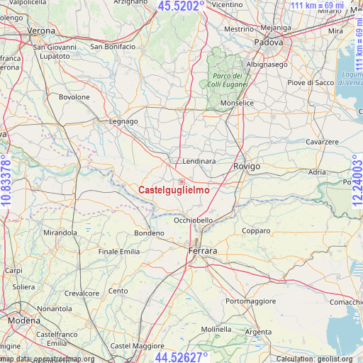
Castelguglielmo GPS coordinates[2]
45° 1' 31.404" North, 11° 32' 12.84" East
| Map corner | latitude | longitude |
|---|---|---|
| Upper-left | 45.5202°, | 10.83378° |
| Center: | 45.02539°, | 11.5369° |
| Lower-right: | 44.52627°, | 12.24003° |
| Map W x H: | 110.5×110.5 km | = 68.7×68.7mi |
| max Lat: | 47.04031° ⇑39.4% North |
| Castelguglielmo: | 45.02539° |
| min Lat: | ⇓60.6% South 35.50142° |
| min Long | Castelguglielmo | max Long |
| 6.69888° | 11.5369° | 18.48682° |
| W 49.9%⇐ | ⇒50.1% E |
Elevation
Elevation of Castelguglielmo is 9 m = 30 ft, and this is 297.7 m = 977 ft below average elevation for this country.
| Max E: |
2085 m = 6841 ft | 94.8% |
| Avg. | 306.7 m = 1006 ft | |
| Castelguglielmo | 9 m = 30 ft | |
Min E: |
-4 m = -13 ft | 5.2% |
See also: Italy elevation on elevation.city.
Geographical zone
Castelguglielmo is located in North temperate zone (between Tropic of Cancer and the Arctic Circle). Distance of this North polar circle is 2394.8 km =1488.1 mi to North.| Distance of | km | miles | from Castelguglielmo |
|---|---|---|---|
| North Pole | 5000.7 | 3107.3 | to North |
| Arctic Circle | 2394.8 | 1488.1 | to North |
| Tropic Cancer | 2400.4 | 1491.5 | to South |
| Equator | 5006.4 | 3110.8 | to South |


Nearby cities:
15 places around Castelguglielmo: (largest is in red/bold)
• Badia Polesine
8.4 km =5.2 mi,  336°
336°
• Bagnolo di Po
3 km =1.9 mi,  248°
248°
• Baruchella
8 km =5 mi,  304°
304°
• Canda
2.9 km =1.8 mi,  294°
294°
• Fiesso Umbertiano
9 km =5.6 mi,  143°
143°
• Fratta Polesine
8.3 km =5.2 mi,  87°
87°
• Giacciano con Baruchella
8.2 km =5.1 mi, 304°
• Lendinara
8.3 km =5.2 mi,  39°
39°
• Pincara
7.2 km =4.5 mi,  112°
112°
• Ramodipalo Rasa
6.3 km =3.9 mi,  17°
17°
• Sabbioni-Zampine
8.2 km =5.1 mi,  188°
188°
• San Bellino
4.4 km =2.7 mi,  84°
84°
• Stienta
9.5 km =5.9 mi,  176°
176°
• Trecenta
6.1 km =3.8 mi,  274°
274°
• Villanova del Ghebbo Canton
9.2 km =5.7 mi,  65°
65°
Sources, notices
• [Note1] Compared only with cities in Italy existing in our database
• [Src1] Map data: © OpenStreetMap contributors (CC-BY-SA)
• [Src2] Other city data from geonames.org with taken over terms of usage.
• [Src3] Geographical zone / Annual Mean Temperature by Robert A. Rohde @ Wikipedia
