Canda geodata
Canda (Veneto) is a seat of a third-order administrative division; located in Italy in Europe/Rome (GMT+2) time zone. With population of 658 people, there are 8573 cities with bigger population in this country. Compared to other cities in Italy, 60.8% of cities are located further ↓South; 50.5% of cities are located further →East and 96.6% of cities have higher elevation than Canda. Note1


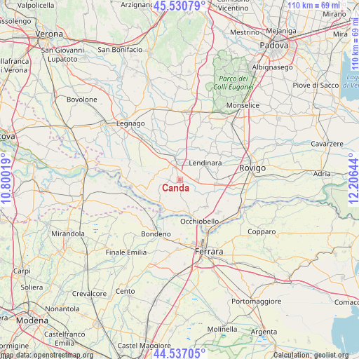
Canda GPS coordinates[2]
45° 2' 9.888" North, 11° 30' 11.916" East
| Map corner | latitude | longitude |
|---|---|---|
| Upper-left | 45.53079°, | 10.80019° |
| Center: | 45.03608°, | 11.50331° |
| Lower-right: | 44.53705°, | 12.20644° |
| Map W x H: | 110.5×110.5 km | = 68.7×68.7mi |
| max Lat: | 47.04031° ⇑39.2% North |
| Canda: | 45.03608° |
| min Lat: | ⇓60.8% South 35.50142° |
| min Long | Canda | max Long |
| 6.69888° | 11.50331° | 18.48682° |
| W 49.5%⇐ | ⇒50.5% E |
Elevation
Elevation of Canda is 6 m = 20 ft, and this is 300.7 m = 987 ft below average elevation for this country.
| Max E: |
2085 m = 6841 ft | 96.6% |
| Avg. | 306.7 m = 1006 ft | |
| Canda | 6 m = 20 ft | |
Min E: |
-4 m = -13 ft | 3.4% |
See also: Italy elevation on elevation.city.
Geographical zone
Canda is located in North temperate zone (between Tropic of Cancer and the Arctic Circle). Distance of this North polar circle is 2393.6 km =1487.3 mi to North.| Distance of | km | miles | from Canda |
|---|---|---|---|
| North Pole | 4999.5 | 3106.5 | to North |
| Arctic Circle | 2393.6 | 1487.3 | to North |
| Tropic Cancer | 2401.6 | 1492.3 | to South |
| Equator | 5007.5 | 3111.5 | to South |


Nearby cities:
15 places around Canda: (largest is in red/bold)
• Badia Polesine
6.6 km =4.1 mi,  353°
353°
• Bagnolo di Po
2.3 km =1.4 mi,  184°
184°
• Baruchella
5.2 km =3.2 mi,  309°
309°
• Castelguglielmo
2.9 km =1.8 mi,  114°
114°
• Giacciano con Baruchella
5.4 km =3.4 mi, 309°
• Lendinara
9.4 km =5.8 mi,  56°
56°
• Masi
8.2 km =5.1 mi, 352°
• Menà
8 km =5 mi,  317°
317°
• Pincara
10.1 km =6.3 mi, 113°
• Ramodipalo Rasa
6.6 km =4.1 mi,  43°
43°
• Sabbioni-Zampine
9.4 km =5.8 mi,  171°
171°
• Salara
8.2 km =5.1 mi,  227°
227°
• San Bellino
7 km =4.3 mi,  96°
96°
• Trecenta
3.5 km =2.2 mi,  257°
257°
• Villa d'Adige
9.7 km =6 mi,  327°
327°
Sources, notices
• [Note1] Compared only with cities in Italy existing in our database
• [Src1] Map data: © OpenStreetMap contributors (CC-BY-SA)
• [Src2] Other city data from geonames.org with taken over terms of usage.
• [Src3] Geographical zone / Annual Mean Temperature by Robert A. Rohde @ Wikipedia
