Labro geodata
Labro (Latium) is a seat of a third-order administrative division; located in Italy in Europe/Rome (GMT+2) time zone. With population of 142 people, there are 11304 cities with bigger population in this country. Compared to other cities in Italy, 66.1% of cities are located further ↑North; 66.2% of cities are located further ←West and 84.9% of cities have lower elevation than Labro. Note1


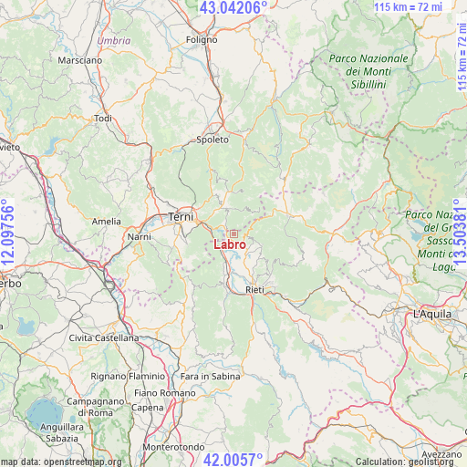
Labro GPS coordinates[2]
42° 31' 33.708" North, 12° 48' 2.448" East
| Map corner | latitude | longitude |
|---|---|---|
| Upper-left | 43.04206°, | 12.09756° |
| Center: | 42.52603°, | 12.80068° |
| Lower-right: | 42.0057°, | 13.50381° |
| Map W x H: | 115.2×115.2 km | = 71.6×71.6mi |
| max Lat: | 47.04031° ⇑66.1% North |
| Labro: | 42.52603° |
| min Lat: | ⇓33.9% South 35.50142° |
| min Long | Labro | max Long |
| 6.69888° | 12.80068° | 18.48682° |
| W 66.2%⇐ | ⇒33.8% E |
Elevation
Elevation of Labro is 609 m = 1998 ft, and this is 302.3 m = 992 ft above average elevation for this country.
| Max E: |
2085 m = 6841 ft | 15.1% |
| Labro | 609 m 1998 ft | |
| Avg. | 306.7 m = 1006 ft | |
Min E: |
-4 m = -13 ft | 84.9% |
See also: Italy elevation on elevation.city.
Geographical zone
Labro is located in North temperate zone (between Tropic of Cancer and the Arctic Circle). Distance of this Northern Tropic circle is 2122.5 km =1318.9 mi to South.| Distance of | km | miles | from Labro |
|---|---|---|---|
| North Pole | 5278.6 | 3280 | to North |
| Arctic Circle | 2672.7 | 1660.7 | to North |
| Tropic Cancer | 2122.5 | 1318.9 | to South |
| Equator | 4728.5 | 2938.2 | to South |


Nearby cities:
15 places around Labro: (largest is in red/bold)
• Arrone
6.9 km =4.3 mi,  336°
336°
• Borgo San Pietro
7.5 km =4.7 mi,  117°
117°
• Cantalice
10.9 km =6.8 mi,  128°
128°
• Colli sul Velino
3.5 km =2.2 mi,  206°
206°
• Contigliano
13.1 km =8.1 mi,  190°
190°
• Ferentillo
10.5 km =6.5 mi,  354°
354°
• Limiti di Greccio
8.5 km =5.3 mi,  197°
197°
• Marmore
7.5 km =4.7 mi,  289°
289°
• Montefranco
8.6 km =5.3 mi, 339°
• Morro Reatino
2.8 km =1.7 mi,  98°
98°
• Poggio Bustone
7.4 km =4.6 mi,  110°
110°
• Polino
7.4 km =4.6 mi,  28°
28°
• Rivodutri
4.6 km =2.9 mi, 102°
• Santa Croce
11.4 km =7.1 mi, 124°
• Stroncone
12.6 km =7.8 mi,  262°
262°
Sources, notices
• [Note1] Compared only with cities in Italy existing in our database
• [Src1] Map data: © OpenStreetMap contributors (CC-BY-SA)
• [Src2] Other city data from geonames.org with taken over terms of usage.
• [Src3] Geographical zone / Annual Mean Temperature by Robert A. Rohde @ Wikipedia
