Istrana geodata
Istrana (Veneto) is a seat of a third-order administrative division; located in Italy in Europe/Rome (GMT+2) time zone. With population of 3,665 people, there are 2576 cities with bigger population in this country. Compared to other cities in Italy, 80.2% of cities are located further ↓South; 57.3% of cities are located further ←West and 83.7% of cities have higher elevation than Istrana. Note1


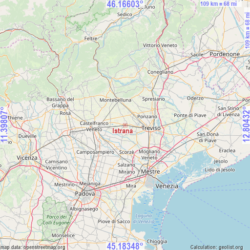
Istrana GPS coordinates[2]
45° 40' 36.876" North, 12° 6' 4.284" East
| Map corner | latitude | longitude |
|---|---|---|
| Upper-left | 46.16603°, | 11.39807° |
| Center: | 45.67691°, | 12.10119° |
| Lower-right: | 45.18348°, | 12.80432° |
| Map W x H: | 109.2×109.2 km | = 67.9×67.9mi |
| max Lat: | 47.04031° ⇑19.8% North |
| Istrana: | 45.67691° |
| min Lat: | ⇓80.2% South 35.50142° |
| min Long | Istrana | max Long |
| 6.69888° | 12.10119° | 18.48682° |
| W 57.3%⇐ | ⇒42.7% E |
Elevation
Elevation of Istrana is 35 m = 115 ft, and this is 271.7 m = 891 ft below average elevation for this country.
| Max E: |
2085 m = 6841 ft | 83.7% |
| Avg. | 306.7 m = 1006 ft | |
| Istrana | 35 m = 115 ft | |
Min E: |
-4 m = -13 ft | 16.3% |
See also: Italy elevation on elevation.city.
Geographical zone
Istrana is located in North temperate zone (between Tropic of Cancer and the Arctic Circle). Distance of this North polar circle is 2322.4 km =1443.1 mi to North.| Distance of | km | miles | from Istrana |
|---|---|---|---|
| North Pole | 4928.3 | 3062.3 | to North |
| Arctic Circle | 2322.4 | 1443.1 | to North |
| Tropic Cancer | 2472.9 | 1536.6 | to South |
| Equator | 5078.8 | 3155.8 | to South |


Nearby cities:
15 places around Istrana: (largest is in red/bold)
• Badoere
4.9 km =3 mi,  194°
194°
• Carpenedo
3.4 km =2.1 mi,  266°
266°
• Casacorba
5.2 km =3.2 mi,  248°
248°
• Cavasagra
4 km =2.5 mi, 245°
• Fossalunga
4.1 km =2.5 mi,  293°
293°
• Musano
5.7 km =3.5 mi,  13°
13°
• Ospedaletto
2.4 km =1.5 mi,  226°
226°
• Padernello
2.1 km =1.3 mi,  75°
75°
• Paese
4.9 km =3 mi,  93°
93°
• Pezzan
1.9 km =1.2 mi,  347°
347°
• Porcellengo
4.6 km =2.9 mi,  44°
44°
• Postioma
6 km =3.7 mi, 41°
• Quinto di Treviso
6.2 km =3.9 mi,  126°
126°
• Sala
3 km =1.9 mi, 350°
• Santa Cristina
4.7 km =2.9 mi,  141°
141°
Sources, notices
• [Note1] Compared only with cities in Italy existing in our database
• [Src1] Map data: © OpenStreetMap contributors (CC-BY-SA)
• [Src2] Other city data from geonames.org with taken over terms of usage.
• [Src3] Geographical zone / Annual Mean Temperature by Robert A. Rohde @ Wikipedia
