Porcellengo geodata
Porcellengo (Veneto) is a populated place; located in Italy in Europe/Rome (GMT+2) time zone. With population of 1,307 people, there are 5615 cities with bigger population in this country. Compared to other cities in Italy, 81.5% of cities are located further ↓South; 57.9% of cities are located further ←West and 80.3% of cities have higher elevation than Porcellengo. Note1


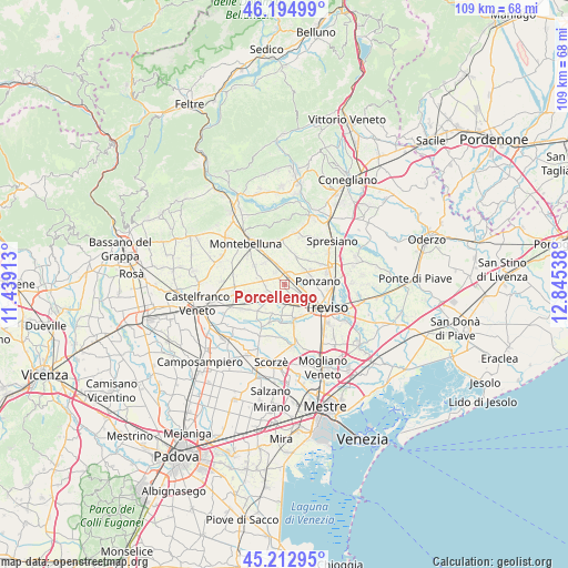
Porcellengo GPS coordinates[2]
45° 42' 22.068" North, 12° 8' 32.1" East
| Map corner | latitude | longitude |
|---|---|---|
| Upper-left | 46.19499°, | 11.43913° |
| Center: | 45.70613°, | 12.14225° |
| Lower-right: | 45.21295°, | 12.84538° |
| Map W x H: | 109.2×109.2 km | = 67.9×67.9mi |
| max Lat: | 47.04031° ⇑18.5% North |
| Porcellengo: | 45.70613° |
| min Lat: | ⇓81.5% South 35.50142° |
| min Long | Porcellengo | max Long |
| 6.69888° | 12.14225° | 18.48682° |
| W 57.9%⇐ | ⇒42.1% E |
Elevation
Elevation of Porcellengo is 48 m = 157 ft, and this is 258.7 m = 849 ft below average elevation for this country.
| Max E: |
2085 m = 6841 ft | 80.3% |
| Avg. | 306.7 m = 1006 ft | |
| Porcellengo | 48 m = 157 ft | |
Min E: |
-4 m = -13 ft | 19.7% |
See also: Italy elevation on elevation.city.
Geographical zone
Porcellengo is located in North temperate zone (between Tropic of Cancer and the Arctic Circle). Distance of this North polar circle is 2319.1 km =1441 mi to North.| Distance of | km | miles | from Porcellengo |
|---|---|---|---|
| North Pole | 4925 | 3060.3 | to North |
| Arctic Circle | 2319.1 | 1441 | to North |
| Tropic Cancer | 2476.1 | 1538.6 | to South |
| Equator | 5082 | 3157.8 | to South |


Nearby cities:
15 places around Porcellengo: (largest is in red/bold)
• Camalò
5.7 km =3.5 mi,  23°
23°
• Castagnole
3.7 km =2.3 mi,  121°
121°
• Falze
5.7 km =3.5 mi,  317°
317°
• Falzè-Signoressa
5.6 km =3.5 mi,  331°
331°
• Istrana
4.6 km =2.9 mi,  224°
224°
• Musano
2.9 km =1.8 mi, 320°
• Padernello
3 km =1.9 mi,  203°
203°
• Paese
3.9 km =2.4 mi,  154°
154°
• Pezzan
3.8 km =2.4 mi,  248°
248°
• Ponzano
4.9 km =3 mi,  77°
77°
• Postioma
1.5 km =0.9 mi,  31°
31°
• Sala
3.7 km =2.3 mi,  265°
265°
• Santa Cristina
7 km =4.3 mi,  182°
182°
• Santandrà
6.5 km =4 mi,  44°
44°
• Trevignano
6.7 km =4.2 mi,  300°
300°
Sources, notices
• [Note1] Compared only with cities in Italy existing in our database
• [Src1] Map data: © OpenStreetMap contributors (CC-BY-SA)
• [Src2] Other city data from geonames.org with taken over terms of usage.
• [Src3] Geographical zone / Annual Mean Temperature by Robert A. Rohde @ Wikipedia
