Badoere geodata
Badoere (Veneto) is a seat of a third-order administrative division; located in Italy in Europe/Rome (GMT+2) time zone. With population of 2,165 people, there are 3916 cities with bigger population in this country. Compared to other cities in Italy, 78.4% of cities are located further ↓South; 57.1% of cities are located further ←West and 88.3% of cities have higher elevation than Badoere. Note1


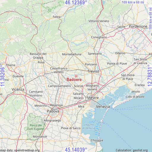
Badoere GPS coordinates[2]
45° 38' 3.12" North, 12° 5' 6.648" East
| Map corner | latitude | longitude |
|---|---|---|
| Upper-left | 46.12369°, | 11.38206° |
| Center: | 45.6342°, | 12.08518° |
| Lower-right: | 45.14039°, | 12.78831° |
| Map W x H: | 109.3×109.3 km | = 67.9×67.9mi |
| max Lat: | 47.04031° ⇑21.6% North |
| Badoere: | 45.6342° |
| min Lat: | ⇓78.4% South 35.50142° |
| min Long | Badoere | max Long |
| 6.69888° | 12.08518° | 18.48682° |
| W 57.1%⇐ | ⇒42.9% E |
Elevation
Elevation of Badoere is 22 m = 72 ft, and this is 284.7 m = 934 ft below average elevation for this country.
| Max E: |
2085 m = 6841 ft | 88.3% |
| Avg. | 306.7 m = 1006 ft | |
| Badoere | 22 m = 72 ft | |
Min E: |
-4 m = -13 ft | 11.7% |
See also: Italy elevation on elevation.city.
Geographical zone
Badoere is located in North temperate zone (between Tropic of Cancer and the Arctic Circle). Distance of this North polar circle is 2327.1 km =1446 mi to North.| Distance of | km | miles | from Badoere |
|---|---|---|---|
| North Pole | 4933 | 3065.2 | to North |
| Arctic Circle | 2327.1 | 1446 | to North |
| Tropic Cancer | 2468.1 | 1533.6 | to South |
| Equator | 5074 | 3152.8 | to South |


Nearby cities:
15 places around Badoere: (largest is in red/bold)
• Carpenedo
5.1 km =3.2 mi,  334°
334°
• Casacorba
4.6 km =2.9 mi,  307°
307°
• Cavasagra
3.9 km =2.4 mi,  322°
322°
• Istrana
4.9 km =3 mi,  14°
14°
• Levada
2.5 km =1.6 mi,  243°
243°
• Ospedaletto
3.1 km =1.9 mi,  350°
350°
• Padernello
6.2 km =3.9 mi,  31°
31°
• Quinto di Treviso
6.3 km =3.9 mi,  80°
80°
• Rio San Martino
5.1 km =3.2 mi,  156°
156°
• Sant'Alberto
4.5 km =2.8 mi,  121°
121°
• Sant'Ambrogio
3.2 km =2 mi,  189°
189°
• Santa Cristina
4.3 km =2.7 mi, 76°
• Scandolara
2.5 km =1.6 mi,  152°
152°
• Torreselle
4.9 km =3 mi,  264°
264°
• Trebaseleghe
5.6 km =3.5 mi,  214°
214°
Sources, notices
• [Note1] Compared only with cities in Italy existing in our database
• [Src1] Map data: © OpenStreetMap contributors (CC-BY-SA)
• [Src2] Other city data from geonames.org with taken over terms of usage.
• [Src3] Geographical zone / Annual Mean Temperature by Robert A. Rohde @ Wikipedia
