Grignasco geodata
Grignasco (Piedmont) is a seat of a third-order administrative division; located in Italy in Europe/Rome (GMT+2) time zone. With population of 3,967 people, there are 2416 cities with bigger population in this country. Compared to other cities in Italy, 80.3% of cities are located further ↓South; 89.6% of cities are located further →East and 62.4% of cities have lower elevation than Grignasco. Note1


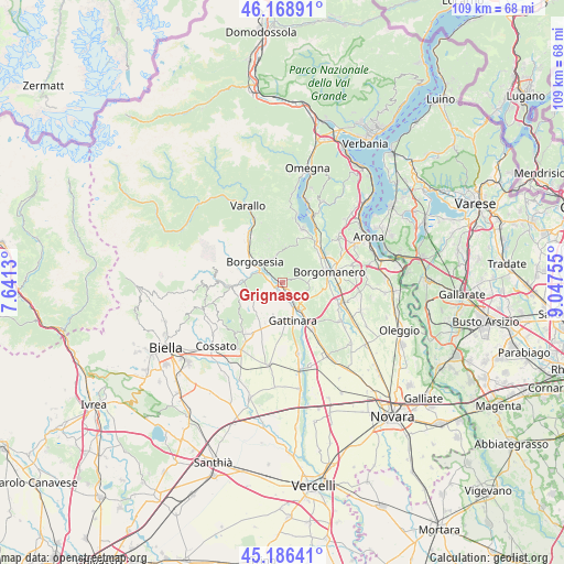
Grignasco GPS coordinates[2]
45° 40' 47.352" North, 8° 20' 39.912" East
| Map corner | latitude | longitude |
|---|---|---|
| Upper-left | 46.16891°, | 7.6413° |
| Center: | 45.67982°, | 8.34442° |
| Lower-right: | 45.18641°, | 9.04755° |
| Map W x H: | 109.2×109.2 km | = 67.9×67.9mi |
| max Lat: | 47.04031° ⇑19.7% North |
| Grignasco: | 45.67982° |
| min Lat: | ⇓80.3% South 35.50142° |
| min Long | Grignasco | max Long |
| 6.69888° | 8.34442° | 18.48682° |
| W 10.4%⇐ | ⇒89.6% E |
Elevation
Elevation of Grignasco is 318 m = 1043 ft, and this is 11.3 m = 37 ft above average elevation for this country.
| Max E: |
2085 m = 6841 ft | 37.6% |
| Grignasco | 318 m 1043 ft | |
| Avg. | 306.7 m = 1006 ft | |
Min E: |
-4 m = -13 ft | 62.4% |
See also: Italy elevation on elevation.city.
Geographical zone
Grignasco is located in North temperate zone (between Tropic of Cancer and the Arctic Circle). Distance of this North polar circle is 2322.1 km =1442.9 mi to North.| Distance of | km | miles | from Grignasco |
|---|---|---|---|
| North Pole | 4927.9 | 3062.1 | to North |
| Arctic Circle | 2322.1 | 1442.9 | to North |
| Tropic Cancer | 2473.2 | 1536.8 | to South |
| Equator | 5079.1 | 3156 | to South |


Nearby cities:
15 places around Grignasco: (largest is in red/bold)
• Boca
5 km =3.1 mi,  91°
91°
• Borgosesia
7.1 km =4.4 mi,  309°
309°
• Cavallirio
4.5 km =2.8 mi,  115°
115°
• Crevacuore
7.8 km =4.8 mi,  274°
274°
• Gargallo
8.3 km =5.2 mi,  49°
49°
• Gattinara
7.6 km =4.7 mi,  168°
168°
• Guardabosone
7.8 km =4.8 mi,  288°
288°
• Lozzolo
7 km =4.3 mi,  193°
193°
• Maggiora
6.1 km =3.8 mi,  80°
80°
• Prato Sesia
3.9 km =2.4 mi,  145°
145°
• Romagnano Sesia
6.2 km =3.9 mi, 147°
• Serravalle Sesia
2.8 km =1.7 mi,  281°
281°
• Soriso
8.4 km =5.2 mi,  36°
36°
• Sostegno
6.5 km =4 mi,  242°
242°
• Valduggia
5.4 km =3.4 mi,  345°
345°
Sources, notices
• [Note1] Compared only with cities in Italy existing in our database
• [Src1] Map data: © OpenStreetMap contributors (CC-BY-SA)
• [Src2] Other city data from geonames.org with taken over terms of usage.
• [Src3] Geographical zone / Annual Mean Temperature by Robert A. Rohde @ Wikipedia
