Lozzolo geodata
Lozzolo (Piedmont) is a seat of a third-order administrative division; located in Italy in Europe/Rome (GMT+2) time zone. With population of 748 people, there are 7967 cities with bigger population in this country. Compared to other cities in Italy, 77.8% of cities are located further ↓South; 89.9% of cities are located further →East and 60.2% of cities have lower elevation than Lozzolo. Note1


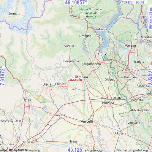
Lozzolo GPS coordinates[2]
45° 37' 8.184" North, 8° 19' 22.224" East
| Map corner | latitude | longitude |
|---|---|---|
| Upper-left | 46.10857°, | 7.61972° |
| Center: | 45.61894°, | 8.32284° |
| Lower-right: | 45.125°, | 9.02597° |
| Map W x H: | 109.4×109.4 km | = 68×68mi |
| max Lat: | 47.04031° ⇑22.2% North |
| Lozzolo: | 45.61894° |
| min Lat: | ⇓77.8% South 35.50142° |
| min Long | Lozzolo | max Long |
| 6.69888° | 8.32284° | 18.48682° |
| W 10.1%⇐ | ⇒89.9% E |
Elevation
Elevation of Lozzolo is 300 m = 984 ft, and this is 6.7 m = 22 ft below average elevation for this country.
| Max E: |
2085 m = 6841 ft | 39.8% |
| Avg. | 306.7 m = 1006 ft | |
| Lozzolo | 300 m = 984 ft | |
Min E: |
-4 m = -13 ft | 60.2% |
See also: Italy elevation on elevation.city.
Geographical zone
Lozzolo is located in North temperate zone (between Tropic of Cancer and the Arctic Circle). Distance of this North polar circle is 2328.8 km =1447 mi to North.| Distance of | km | miles | from Lozzolo |
|---|---|---|---|
| North Pole | 4934.7 | 3066.3 | to North |
| Arctic Circle | 2328.8 | 1447 | to North |
| Tropic Cancer | 2466.4 | 1532.5 | to South |
| Equator | 5072.4 | 3151.8 | to South |


Nearby cities:
15 places around Lozzolo: (largest is in red/bold)
• Brusnengo
6.4 km =4 mi,  239°
239°
• Cavallirio
7.5 km =4.7 mi,  50°
50°
• Curino
6.8 km =4.2 mi,  277°
277°
• Gattinara
3.3 km =2.1 mi,  101°
101°
• Ghemme
7.9 km =4.9 mi,  106°
106°
• Grignasco
7 km =4.3 mi,  13°
13°
• Masserano
8.3 km =5.2 mi,  251°
251°
• Prato Sesia
5.3 km =3.3 mi, 47°
• Roasio
3.4 km =2.1 mi, 241°
• Romagnano Sesia
5.2 km =3.2 mi,  72°
72°
• San Maurizio
3.3 km =2.1 mi, 238°
• Sant'Eusebio
4.8 km =3 mi,  232°
232°
• Serravalle Sesia
7.4 km =4.6 mi,  351°
351°
• Sostegno
5.6 km =3.5 mi,  312°
312°
• Villa del Bosco
3.5 km =2.2 mi,  265°
265°
Sources, notices
• [Note1] Compared only with cities in Italy existing in our database
• [Src1] Map data: © OpenStreetMap contributors (CC-BY-SA)
• [Src2] Other city data from geonames.org with taken over terms of usage.
• [Src3] Geographical zone / Annual Mean Temperature by Robert A. Rohde @ Wikipedia
