Cravagliana geodata
Cravagliana (Piedmont) is a seat of a third-order administrative division; located in Italy in Europe/Rome (GMT+2) time zone. With population of 49 people, there are 11606 cities with bigger population in this country. Compared to other cities in Italy, 87.6% of cities are located further ↓South; 91% of cities are located further →East and 85.9% of cities have lower elevation than Cravagliana. Note1


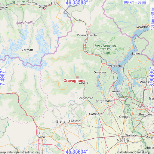
Cravagliana GPS coordinates[2]
45° 50' 53.772" North, 8° 12' 6.552" East
| Map corner | latitude | longitude |
|---|---|---|
| Upper-left | 46.33588°, | 7.4987° |
| Center: | 45.84827°, | 8.20182° |
| Lower-right: | 45.35634°, | 8.90495° |
| Map W x H: | 108.9×108.9 km | = 67.7×67.7mi |
| max Lat: | 47.04031° ⇑12.4% North |
| Cravagliana: | 45.84827° |
| min Lat: | ⇓87.6% South 35.50142° |
| min Long | Cravagliana | max Long |
| 6.69888° | 8.20182° | 18.48682° |
| W 9%⇐ | ⇒91% E |
Elevation
Elevation of Cravagliana is 630 m = 2067 ft, and this is 323.3 m = 1061 ft above average elevation for this country.
| Max E: |
2085 m = 6841 ft | 14.1% |
| Cravagliana | 630 m 2067 ft | |
| Avg. | 306.7 m = 1006 ft | |
Min E: |
-4 m = -13 ft | 85.9% |
See also: Italy elevation on elevation.city.
Geographical zone
Cravagliana is located in North temperate zone (between Tropic of Cancer and the Arctic Circle). Distance of this North polar circle is 2303.3 km =1431.2 mi to North.| Distance of | km | miles | from Cravagliana |
|---|---|---|---|
| North Pole | 4909.2 | 3050.4 | to North |
| Arctic Circle | 2303.3 | 1431.2 | to North |
| Tropic Cancer | 2491.9 | 1548.4 | to South |
| Equator | 5097.8 | 3167.6 | to South |


Nearby cities:
15 places around Cravagliana: (largest is in red/bold)
• Balmuccia
5.8 km =3.6 mi,  235°
235°
• Boccioleto
7.2 km =4.5 mi,  253°
253°
• Cervatto
4.9 km =3 mi,  321°
321°
• Civiasco
8.4 km =5.2 mi,  122°
122°
• Fobello
5.8 km =3.6 mi, 323°
• Massiola
11.6 km =7.2 mi,  52°
52°
• Quarona
11 km =6.8 mi,  152°
152°
• Rimasco
10.7 km =6.6 mi,  277°
277°
• Rimella
6.8 km =4.2 mi,  347°
347°
• Roccapietra
8.4 km =5.2 mi,  136°
136°
• Rossa
6.2 km =3.9 mi, 254°
• Sabbia
2.8 km =1.7 mi,  69°
69°
• Scopa
9.2 km =5.7 mi,  227°
227°
• Varallo
5.8 km =3.6 mi,  131°
131°
• Vocca
1.8 km =1.1 mi,  195°
195°
Sources, notices
• [Note1] Compared only with cities in Italy existing in our database
• [Src1] Map data: © OpenStreetMap contributors (CC-BY-SA)
• [Src2] Other city data from geonames.org with taken over terms of usage.
• [Src3] Geographical zone / Annual Mean Temperature by Robert A. Rohde @ Wikipedia
