Varallo geodata
Varallo (Piedmont) is a seat of a third-order administrative division; located in Italy in Europe/Rome (GMT+2) time zone. With population of 5,427 people, there are 1806 cities with bigger population in this country. Compared to other cities in Italy, 86.4% of cities are located further ↓South; 90.5% of cities are located further →East and 75.1% of cities have lower elevation than Varallo. Note1


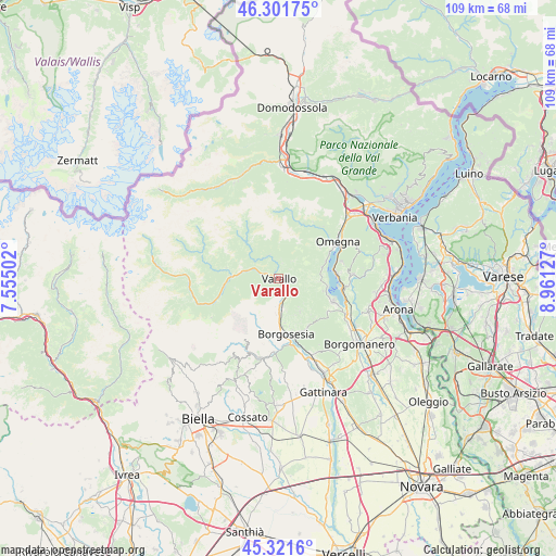
Varallo GPS coordinates[2]
45° 48' 49.788" North, 8° 15' 29.304" East
| Map corner | latitude | longitude |
|---|---|---|
| Upper-left | 46.30175°, | 7.55502° |
| Center: | 45.81383°, | 8.25814° |
| Lower-right: | 45.3216°, | 8.96127° |
| Map W x H: | 109×109 km | = 67.7×67.7mi |
| max Lat: | 47.04031° ⇑13.6% North |
| Varallo: | 45.81383° |
| min Lat: | ⇓86.4% South 35.50142° |
| min Long | Varallo | max Long |
| 6.69888° | 8.25814° | 18.48682° |
| W 9.5%⇐ | ⇒90.5% E |
Elevation
Elevation of Varallo is 453 m = 1486 ft, and this is 146.3 m = 480 ft above average elevation for this country.
| Max E: |
2085 m = 6841 ft | 24.9% |
| Varallo | 453 m 1486 ft | |
| Avg. | 306.7 m = 1006 ft | |
Min E: |
-4 m = -13 ft | 75.1% |
See also: Italy elevation on elevation.city.
Geographical zone
Varallo is located in North temperate zone (between Tropic of Cancer and the Arctic Circle). Distance of this North polar circle is 2307.2 km =1433.6 mi to North.| Distance of | km | miles | from Varallo |
|---|---|---|---|
| North Pole | 4913 | 3052.8 | to North |
| Arctic Circle | 2307.2 | 1433.6 | to North |
| Tropic Cancer | 2488.1 | 1546 | to South |
| Equator | 5094 | 3165.3 | to South |


Nearby cities:
15 places around Varallo: (largest is in red/bold)
• Arola
7.8 km =4.8 mi,  94°
94°
• Balmuccia
9.1 km =5.7 mi,  273°
273°
• Breia
6.6 km =4.1 mi,  145°
145°
• Cellio
7.7 km =4.8 mi, 147°
• Cesara
8.8 km =5.5 mi,  75°
75°
• Civiasco
2.8 km =1.7 mi,  103°
103°
• Cravagliana
5.8 km =3.6 mi,  311°
311°
• Madonna del Sasso
9 km =5.6 mi,  105°
105°
• Nonio
9.9 km =6.2 mi,  68°
68°
• Pella
10 km =6.2 mi, 100°
• Quarna Sotto
10.2 km =6.3 mi,  52°
52°
• Quarona
6 km =3.7 mi,  173°
173°
• Roccapietra
2.7 km =1.7 mi, 148°
• Sabbia
5.1 km =3.2 mi,  340°
340°
• Vocca
5.3 km =3.3 mi,  293°
293°
Sources, notices
• [Note1] Compared only with cities in Italy existing in our database
• [Src1] Map data: © OpenStreetMap contributors (CC-BY-SA)
• [Src2] Other city data from geonames.org with taken over terms of usage.
• [Src3] Geographical zone / Annual Mean Temperature by Robert A. Rohde @ Wikipedia
