Quarona geodata
Quarona (Piedmont) is a seat of a third-order administrative division; located in Italy in Europe/Rome (GMT+2) time zone. With population of 3,558 people, there are 2640 cities with bigger population in this country. Compared to other cities in Italy, 84% of cities are located further ↓South; 90.4% of cities are located further →East and 70.9% of cities have lower elevation than Quarona. Note1


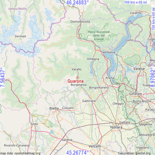
Quarona GPS coordinates[2]
45° 45' 37.584" North, 8° 16' 2.964" East
| Map corner | latitude | longitude |
|---|---|---|
| Upper-left | 46.24883°, | 7.56437° |
| Center: | 45.76044°, | 8.26749° |
| Lower-right: | 45.26774°, | 8.97062° |
| Map W x H: | 109.1×109.1 km | = 67.8×67.8mi |
| max Lat: | 47.04031° ⇑16% North |
| Quarona: | 45.76044° |
| min Lat: | ⇓84% South 35.50142° |
| min Long | Quarona | max Long |
| 6.69888° | 8.26749° | 18.48682° |
| W 9.6%⇐ | ⇒90.4% E |
Elevation
Elevation of Quarona is 403 m = 1322 ft, and this is 96.3 m = 316 ft above average elevation for this country.
| Max E: |
2085 m = 6841 ft | 29.1% |
| Quarona | 403 m 1322 ft | |
| Avg. | 306.7 m = 1006 ft | |
Min E: |
-4 m = -13 ft | 70.9% |
See also: Italy elevation on elevation.city.
Geographical zone
Quarona is located in North temperate zone (between Tropic of Cancer and the Arctic Circle). Distance of this North polar circle is 2313.1 km =1437.3 mi to North.| Distance of | km | miles | from Quarona |
|---|---|---|---|
| North Pole | 4919 | 3056.5 | to North |
| Arctic Circle | 2313.1 | 1437.3 | to North |
| Tropic Cancer | 2482.2 | 1542.4 | to South |
| Equator | 5088.1 | 3161.6 | to South |


Nearby cities:
15 places around Quarona: (largest is in red/bold)
• Ailoche
7.8 km =4.8 mi,  207°
207°
• Arola
8.8 km =5.5 mi,  52°
52°
• Borgosesia
4.5 km =2.8 mi,  172°
172°
• Breia
3 km =1.9 mi,  80°
80°
• Cellio
3.5 km =2.2 mi,  99°
99°
• Civiasco
5.7 km =3.5 mi,  21°
21°
• Crevacuore
8.5 km =5.3 mi,  192°
192°
• Frazione Chiesa
8.5 km =5.3 mi, 210°
• Guardabosone
6.7 km =4.2 mi, 192°
• Madonna del Sasso
8.7 km =5.4 mi,  65°
65°
• Postua
6 km =3.7 mi, 210°
• Roccapietra
3.7 km =2.3 mi,  10°
10°
• Serravalle Sesia
9 km =5.6 mi,  159°
159°
• Valduggia
5.9 km =3.7 mi,  128°
128°
• Varallo
6 km =3.7 mi,  353°
353°
Sources, notices
• [Note1] Compared only with cities in Italy existing in our database
• [Src1] Map data: © OpenStreetMap contributors (CC-BY-SA)
• [Src2] Other city data from geonames.org with taken over terms of usage.
• [Src3] Geographical zone / Annual Mean Temperature by Robert A. Rohde @ Wikipedia
