Giussano geodata
Giussano (Lombardy) is a seat of a third-order administrative division; located in Italy in Europe/Rome (GMT+2) time zone. With population of 24,357 people, there are 335 cities with bigger population in this country. Compared to other cities in Italy, 81.2% of cities are located further ↓South; 77.9% of cities are located further →East and 56.2% of cities have lower elevation than Giussano. Note1
Administrative division(s):
- Level 1: Lombardy
- Level 2: Provincia di Monza e della Brianza
- Level 3: Giussano


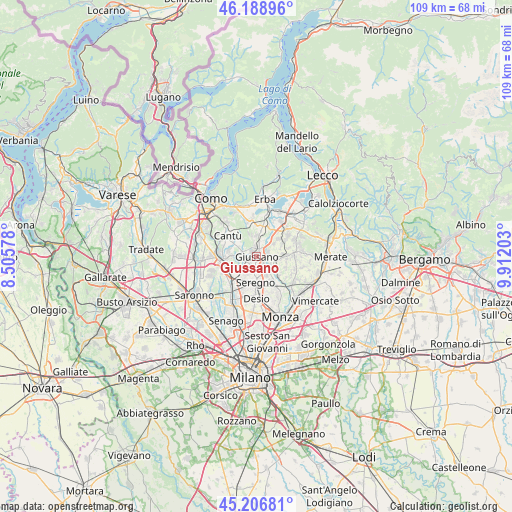
Giussano GPS coordinates[2]
45° 42' 0.144" North, 9° 12' 32.04" East
| Map corner | latitude | longitude |
|---|---|---|
| Upper-left | 46.18896°, | 8.50578° |
| Center: | 45.70004°, | 9.2089° |
| Lower-right: | 45.20681°, | 9.91203° |
| Map W x H: | 109.2×109.2 km | = 67.9×67.9mi |
| max Lat: | 47.04031° ⇑18.8% North |
| Giussano: | 45.70004° |
| min Lat: | ⇓81.2% South 35.50142° |
| min Long | Giussano | max Long |
| 6.69888° | 9.2089° | 18.48682° |
| W 22.1%⇐ | ⇒77.9% E |
Elevation
Elevation of Giussano is 273 m = 896 ft, and this is 33.7 m = 111 ft below average elevation for this country.
| Max E: |
2085 m = 6841 ft | 43.8% |
| Avg. | 306.7 m = 1006 ft | |
| Giussano | 273 m = 896 ft | |
Min E: |
-4 m = -13 ft | 56.2% |
See also: Italy elevation on elevation.city.
Geographical zone
Giussano is located in North temperate zone (between Tropic of Cancer and the Arctic Circle). Distance of this North polar circle is 2319.8 km =1441.5 mi to North.| Distance of | km | miles | from Giussano |
|---|---|---|---|
| North Pole | 4925.7 | 3060.7 | to North |
| Arctic Circle | 2319.8 | 1441.5 | to North |
| Tropic Cancer | 2475.4 | 1538.1 | to South |
| Equator | 5081.4 | 3157.4 | to South |


Nearby cities:
15 places around Giussano: (largest is in red/bold)
• Agliate
2.8 km =1.7 mi,  125°
125°
• Arosio
2.1 km =1.3 mi,  358°
358°
• Briosco
2.7 km =1.7 mi,  65°
65°
• Cabiate
4 km =2.5 mi,  223°
223°
• Calò
4.8 km =3 mi,  118°
118°
• Capriano
4.4 km =2.7 mi,  54°
54°
• Carate Brianza
3.5 km =2.2 mi,  140°
140°
• Carugo
1.3 km =0.8 mi,  315°
315°
• Costa Lambro
3.4 km =2.1 mi, 118°
• Fornaci
3.8 km =2.4 mi,  40°
40°
• Inverigo
4.3 km =2.7 mi,  9°
9°
• Mariano Comense
2.1 km =1.3 mi,  259°
259°
• Verano Brianza
1.8 km =1.1 mi, 136°
• Villa Raverio
4.3 km =2.7 mi,  102°
102°
• Zoccorino-Vergo
3.5 km =2.2 mi,  94°
94°
Sources, notices
• [Note1] Compared only with cities in Italy existing in our database
• [Src1] Map data: © OpenStreetMap contributors (CC-BY-SA)
• [Src2] Other city data from geonames.org with taken over terms of usage.
• [Src3] Geographical zone / Annual Mean Temperature by Robert A. Rohde @ Wikipedia
