Zoccorino-Vergo geodata
Zoccorino-Vergo (Lombardy) is a populated place; located in Italy in Europe/Rome (GMT+2) time zone. With population of 2,115 people, there are 3963 cities with bigger population in this country. Compared to other cities in Italy, 81.1% of cities are located further ↓South; 77.2% of cities are located further →East and 58.2% of cities have lower elevation than Zoccorino-Vergo. Note1
Administrative division(s):
- Level 1: Lombardy
- Level 2: Provincia di Monza e della Brianza
- Level 3: Besana in Brianza


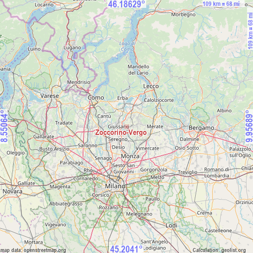
Zoccorino-Vergo GPS coordinates[2]
45° 41' 50.46" North, 9° 15' 13.572" East
| Map corner | latitude | longitude |
|---|---|---|
| Upper-left | 46.18629°, | 8.55064° |
| Center: | 45.69735°, | 9.25377° |
| Lower-right: | 45.2041°, | 9.95689° |
| Map W x H: | 109.2×109.2 km | = 67.9×67.9mi |
| max Lat: | 47.04031° ⇑18.9% North |
| Zoccorino-Vergo: | 45.69735° |
| min Lat: | ⇓81.1% South 35.50142° |
| min Long | Zoccorino-Vergo | max Long |
| 6.69888° | 9.25377° | 18.48682° |
| W 22.8%⇐ | ⇒77.2% E |
Elevation
Elevation of Zoccorino-Vergo is 287 m = 942 ft, and this is 19.7 m = 65 ft below average elevation for this country.
| Max E: |
2085 m = 6841 ft | 41.8% |
| Avg. | 306.7 m = 1006 ft | |
| Zoccorino-Vergo | 287 m = 942 ft | |
Min E: |
-4 m = -13 ft | 58.2% |
See also: Italy elevation on elevation.city.
Geographical zone
Zoccorino-Vergo is located in North temperate zone (between Tropic of Cancer and the Arctic Circle). Distance of this North polar circle is 2320.1 km =1441.6 mi to North.| Distance of | km | miles | from Zoccorino-Vergo |
|---|---|---|---|
| North Pole | 4926 | 3060.9 | to North |
| Arctic Circle | 2320.1 | 1441.6 | to North |
| Tropic Cancer | 2475.2 | 1538 | to South |
| Equator | 5081.1 | 3157.2 | to South |


Nearby cities:
15 places around Zoccorino-Vergo: (largest is in red/bold)
• Agliate
1.8 km =1.1 mi,  221°
221°
• Besana in Brianza
3.2 km =2 mi,  80°
80°
• Briosco
1.7 km =1.1 mi,  324°
324°
• Calò
2.2 km =1.4 mi,  160°
160°
• Capriano
2.9 km =1.8 mi,  2°
2°
• Carate Brianza
2.7 km =1.7 mi,  208°
208°
• Cortenuova
4 km =2.5 mi,  59°
59°
• Costa Lambro
1.4 km =0.9 mi,  200°
200°
• Fornaci
3.4 km =2.1 mi,  342°
342°
• Giussano
3.5 km =2.2 mi,  274°
274°
• Renate
3.6 km =2.2 mi,  34°
34°
• Tregasio
3.4 km =2.1 mi,  129°
129°
• Triuggio
4.1 km =2.5 mi,  165°
165°
• Verano Brianza
2.5 km =1.6 mi,  246°
246°
• Villa Raverio
0.9 km =0.6 mi, 132°
Sources, notices
• [Note1] Compared only with cities in Italy existing in our database
• [Src1] Map data: © OpenStreetMap contributors (CC-BY-SA)
• [Src2] Other city data from geonames.org with taken over terms of usage.
• [Src3] Geographical zone / Annual Mean Temperature by Robert A. Rohde @ Wikipedia
