Giarole geodata
Giarole (Piedmont) is a seat of a third-order administrative division; located in Italy in Europe/Rome (GMT+2) time zone. With population of 702 people, there are 8285 cities with bigger population in this country. Compared to other cities in Italy, 61.5% of cities are located further ↓South; 87.1% of cities are located further →East and 69.2% of cities have higher elevation than Giarole. Note1


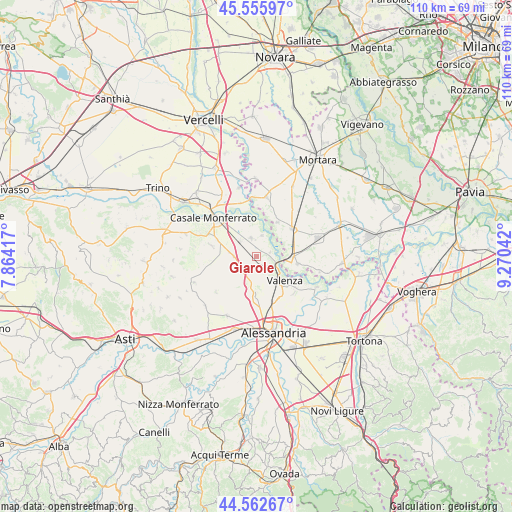
Giarole GPS coordinates[2]
45° 3' 41.328" North, 8° 34' 2.28" East
| Map corner | latitude | longitude |
|---|---|---|
| Upper-left | 45.55597°, | 7.86417° |
| Center: | 45.06148°, | 8.5673° |
| Lower-right: | 44.56267°, | 9.27042° |
| Map W x H: | 110.4×110.4 km | = 68.6×68.6mi |
| max Lat: | 47.04031° ⇑38.5% North |
| Giarole: | 45.06148° |
| min Lat: | ⇓61.5% South 35.50142° |
| min Long | Giarole | max Long |
| 6.69888° | 8.5673° | 18.48682° |
| W 12.9%⇐ | ⇒87.1% E |
Elevation
Elevation of Giarole is 102 m = 335 ft, and this is 204.7 m = 672 ft below average elevation for this country.
| Max E: |
2085 m = 6841 ft | 69.2% |
| Avg. | 306.7 m = 1006 ft | |
| Giarole | 102 m = 335 ft | |
Min E: |
-4 m = -13 ft | 30.8% |
See also: Italy elevation on elevation.city.
Geographical zone
Giarole is located in North temperate zone (between Tropic of Cancer and the Arctic Circle). Distance of this North polar circle is 2390.8 km =1485.6 mi to North.| Distance of | km | miles | from Giarole |
|---|---|---|---|
| North Pole | 4996.7 | 3104.8 | to North |
| Arctic Circle | 2390.8 | 1485.6 | to North |
| Tropic Cancer | 2404.4 | 1494 | to South |
| Equator | 5010.4 | 3113.3 | to South |


Nearby cities:
15 places around Giarole: (largest is in red/bold)
• Borgo San Martino
4.9 km =3 mi,  315°
315°
• Bozzole
3.1 km =1.9 mi,  73°
73°
• Breme
8.7 km =5.4 mi,  31°
31°
• Castelletto Monferrato
8.9 km =5.5 mi,  181°
181°
• Frascarolo
9.2 km =5.7 mi,  100°
100°
• Frassineto Po
8.3 km =5.2 mi,  342°
342°
• Lu
9.2 km =5.7 mi,  224°
224°
• Mirabello Monferrato
4.5 km =2.8 mi,  229°
229°
• Occimiano
4.8 km =3 mi,  267°
267°
• Pomaro Monferrato
2.3 km =1.4 mi,  87°
87°
• San Salvatore Monferrato
7.4 km =4.6 mi, 180°
• Ticineto
4 km =2.5 mi, 343°
• Torre Beretti
8.1 km =5 mi, 91°
• Valenza
8.1 km =5 mi,  132°
132°
• Valmacca
4.6 km =2.9 mi,  16°
16°
Sources, notices
• [Note1] Compared only with cities in Italy existing in our database
• [Src1] Map data: © OpenStreetMap contributors (CC-BY-SA)
• [Src2] Other city data from geonames.org with taken over terms of usage.
• [Src3] Geographical zone / Annual Mean Temperature by Robert A. Rohde @ Wikipedia
