Ghilarza geodata
Ghilarza (Sardinia) is a seat of a third-order administrative division; located in Italy in Europe/Rome (GMT+2) time zone. With population of 4,467 people, there are 2159 cities with bigger population in this country. Compared to other cities in Italy, 87% of cities are located further ↑North; 83.6% of cities are located further →East and 59% of cities have lower elevation than Ghilarza. Note1


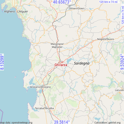
Ghilarza GPS coordinates[2]
40° 7' 16.284" North, 8° 50' 10.032" East
| Map corner | latitude | longitude |
|---|---|---|
| Upper-left | 40.65673°, | 8.13299° |
| Center: | 40.12119°, | 8.83612° |
| Lower-right: | 39.5814°, | 9.53924° |
| Map W x H: | 119.6×119.6 km | = 74.3×74.3mi |
| max Lat: | 47.04031° ⇑87% North |
| Ghilarza: | 40.12119° |
| min Lat: | ⇓13% South 35.50142° |
| min Long | Ghilarza | max Long |
| 6.69888° | 8.83612° | 18.48682° |
| W 16.4%⇐ | ⇒83.6% E |
Elevation
Elevation of Ghilarza is 292 m = 958 ft, and this is 14.7 m = 48 ft below average elevation for this country.
| Max E: |
2085 m = 6841 ft | 41% |
| Avg. | 306.7 m = 1006 ft | |
| Ghilarza | 292 m = 958 ft | |
Min E: |
-4 m = -13 ft | 59% |
See also: Italy elevation on elevation.city.
Geographical zone
Ghilarza is located in North temperate zone (between Tropic of Cancer and the Arctic Circle). Distance of this Northern Tropic circle is 1855.1 km =1152.7 mi to South.| Distance of | km | miles | from Ghilarza |
|---|---|---|---|
| North Pole | 5546 | 3446.1 | to North |
| Arctic Circle | 2940.1 | 1826.9 | to North |
| Tropic Cancer | 1855.1 | 1152.7 | to South |
| Equator | 4461.1 | 2772 | to South |


Nearby cities:
15 places around Ghilarza: (largest is in red/bold)
• Abbasanta
1.8 km =1.1 mi,  296°
296°
• Aidomaggiore
5.9 km =3.7 mi,  17°
17°
• Ardauli
7.7 km =4.8 mi,  122°
122°
• Bidonì
8.6 km =5.3 mi,  96°
96°
• Boroneddu
3.1 km =1.9 mi,  108°
108°
• Borore
10.9 km =6.8 mi,  345°
345°
• Busachi
10.6 km =6.6 mi,  155°
155°
• Norbello
1.5 km =0.9 mi, 347°
• Nughedu Santa Vittoria
10.1 km =6.3 mi, 102°
• Paulilatino
7.3 km =4.5 mi,  236°
236°
• Sedilo
9.2 km =5.7 mi,  51°
51°
• Soddì
3.7 km =2.3 mi,  74°
74°
• Sorradile
8.3 km =5.2 mi, 101°
• Tadasuni
4.2 km =2.6 mi, 107°
• Ulà Tirso
10.2 km =6.3 mi,  145°
145°
Sources, notices
• [Note1] Compared only with cities in Italy existing in our database
• [Src1] Map data: © OpenStreetMap contributors (CC-BY-SA)
• [Src2] Other city data from geonames.org with taken over terms of usage.
• [Src3] Geographical zone / Annual Mean Temperature by Robert A. Rohde @ Wikipedia
