Abbasanta geodata
Abbasanta (Sardinia) is a seat of a third-order administrative division; located in Italy in Europe/Rome (GMT+2) time zone. With population of 2,746 people, there are 3271 cities with bigger population in this country. Compared to other cities in Italy, 86.9% of cities are located further ↑North; 83.9% of cities are located further →East and 62.3% of cities have lower elevation than Abbasanta. Note1


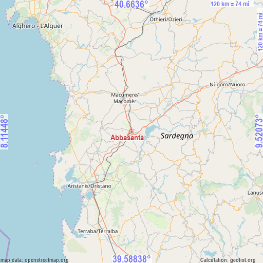
Abbasanta GPS coordinates[2]
40° 7' 41.232" North, 8° 49' 3.36" East
| Map corner | latitude | longitude |
|---|---|---|
| Upper-left | 40.6636°, | 8.11448° |
| Center: | 40.12812°, | 8.8176° |
| Lower-right: | 39.58838°, | 9.52073° |
| Map W x H: | 119.6×119.6 km | = 74.3×74.3mi |
| max Lat: | 47.04031° ⇑86.9% North |
| Abbasanta: | 40.12812° |
| min Lat: | ⇓13.1% South 35.50142° |
| min Long | Abbasanta | max Long |
| 6.69888° | 8.8176° | 18.48682° |
| W 16.1%⇐ | ⇒83.9% E |
Elevation
Elevation of Abbasanta is 317 m = 1040 ft, and this is 10.3 m = 34 ft above average elevation for this country.
| Max E: |
2085 m = 6841 ft | 37.7% |
| Abbasanta | 317 m 1040 ft | |
| Avg. | 306.7 m = 1006 ft | |
Min E: |
-4 m = -13 ft | 62.3% |
See also: Italy elevation on elevation.city.
Geographical zone
Abbasanta is located in North temperate zone (between Tropic of Cancer and the Arctic Circle). Distance of this Northern Tropic circle is 1855.9 km =1153.2 mi to South.| Distance of | km | miles | from Abbasanta |
|---|---|---|---|
| North Pole | 5545.2 | 3445.6 | to North |
| Arctic Circle | 2939.3 | 1826.4 | to North |
| Tropic Cancer | 1855.9 | 1153.2 | to South |
| Equator | 4461.8 | 2772.4 | to South |


Nearby cities:
15 places around Abbasanta: (largest is in red/bold)
• Aidomaggiore
5.9 km =3.7 mi,  34°
34°
• Ardauli
9.4 km =5.8 mi,  121°
121°
• Bidonì
10.2 km =6.3 mi,  99°
99°
• Boroneddu
4.8 km =3 mi,  111°
111°
• Borore
9.8 km =6.1 mi,  353°
353°
• Busachi
12.1 km =7.5 mi,  149°
149°
• Ghilarza
1.8 km =1.1 mi, 116°
• Norbello
1.4 km =0.9 mi,  58°
58°
• Nughedu Santa Vittoria
11.8 km =7.3 mi, 104°
• Paulilatino
6.6 km =4.1 mi,  223°
223°
• Sedilo
10 km =6.2 mi, 60°
• Soddì
5.1 km =3.2 mi,  87°
87°
• Sorradile
10.1 km =6.3 mi, 103°
• Tadasuni
6 km =3.7 mi, 109°
• Ulà Tirso
11.7 km =7.3 mi,  141°
141°
Sources, notices
• [Note1] Compared only with cities in Italy existing in our database
• [Src1] Map data: © OpenStreetMap contributors (CC-BY-SA)
• [Src2] Other city data from geonames.org with taken over terms of usage.
• [Src3] Geographical zone / Annual Mean Temperature by Robert A. Rohde @ Wikipedia
