Gessopalena geodata
Gessopalena (Abruzzo) is a seat of a third-order administrative division; located in Italy in Europe/Rome (GMT+2) time zone. With population of 1,013 people, there are 6616 cities with bigger population in this country. Compared to other cities in Italy, 69.9% of cities are located further ↑North; 80.6% of cities are located further ←West and 86.8% of cities have lower elevation than Gessopalena. Note1


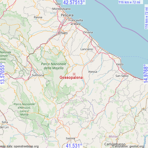
Gessopalena GPS coordinates[2]
42° 3' 18.756" North, 14° 16' 25.212" East
| Map corner | latitude | longitude |
|---|---|---|
| Upper-left | 42.57513°, | 13.57055° |
| Center: | 42.05521°, | 14.27367° |
| Lower-right: | 41.531°, | 14.9768° |
| Map W x H: | 116.1×116.1 km | = 72.1×72.1mi |
| max Lat: | 47.04031° ⇑69.9% North |
| Gessopalena: | 42.05521° |
| min Lat: | ⇓30.1% South 35.50142° |
| min Long | Gessopalena | max Long |
| 6.69888° | 14.27367° | 18.48682° |
| W 80.6%⇐ | ⇒19.4% E |
Elevation
Elevation of Gessopalena is 648 m = 2126 ft, and this is 341.3 m = 1120 ft above average elevation for this country.
| Max E: |
2085 m = 6841 ft | 13.2% |
| Gessopalena | 648 m 2126 ft | |
| Avg. | 306.7 m = 1006 ft | |
Min E: |
-4 m = -13 ft | 86.8% |
See also: Italy elevation on elevation.city.
Geographical zone
Gessopalena is located in North temperate zone (between Tropic of Cancer and the Arctic Circle). Distance of this Northern Tropic circle is 2070.2 km =1286.4 mi to South.| Distance of | km | miles | from Gessopalena |
|---|---|---|---|
| North Pole | 5331 | 3312.5 | to North |
| Arctic Circle | 2725.1 | 1693.3 | to North |
| Tropic Cancer | 2070.2 | 1286.4 | to South |
| Equator | 4676.1 | 2905.6 | to South |


Nearby cities:
15 places around Gessopalena: (largest is in red/bold)
• Altino
6.9 km =4.3 mi,  44°
44°
• Bomba
8 km =5 mi,  107°
107°
• Casoli
6.7 km =4.2 mi,  11°
11°
• Civitella Messer Raimondo
6 km =3.7 mi,  308°
308°
• Colledimacine
8.3 km =5.2 mi,  226°
226°
• Fara San Martino
6.8 km =4.2 mi, 307°
• Lama dei Peligni
7.3 km =4.5 mi,  258°
258°
• Montebello sul Sangro
8.7 km =5.4 mi,  151°
151°
• Montenerodomo
8.9 km =5.5 mi,  191°
191°
• Palombaro
8.4 km =5.2 mi,  334°
334°
• Pennadomo
7 km =4.3 mi,  144°
144°
• Roccascalegna
2.9 km =1.8 mi,  74°
74°
• Selva
8.8 km =5.5 mi, 41°
• Taranta Peligna
9.3 km =5.8 mi,  245°
245°
• Torricella Peligna
3.7 km =2.3 mi,  199°
199°
Sources, notices
• [Note1] Compared only with cities in Italy existing in our database
• [Src1] Map data: © OpenStreetMap contributors (CC-BY-SA)
• [Src2] Other city data from geonames.org with taken over terms of usage.
• [Src3] Geographical zone / Annual Mean Temperature by Robert A. Rohde @ Wikipedia
