Gavirate geodata
Gavirate (Lombardy) is a seat of a third-order administrative division; located in Italy in Europe/Rome (GMT+2) time zone. With population of 9,206 people, there are 1030 cities with bigger population in this country. Compared to other cities in Italy, 87.3% of cities are located further ↓South; 85.2% of cities are located further →East and 51.2% of cities have lower elevation than Gavirate. Note1


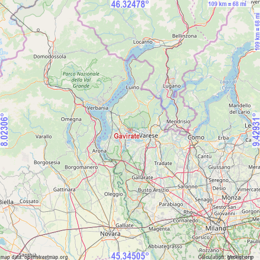
Gavirate GPS coordinates[2]
45° 50' 13.452" North, 8° 43' 34.284" East
| Map corner | latitude | longitude |
|---|---|---|
| Upper-left | 46.32478°, | 8.02306° |
| Center: | 45.83707°, | 8.72619° |
| Lower-right: | 45.34505°, | 9.42931° |
| Map W x H: | 108.9×108.9 km | = 67.7×67.7mi |
| max Lat: | 47.04031° ⇑12.7% North |
| Gavirate: | 45.83707° |
| min Lat: | ⇓87.3% South 35.50142° |
| min Long | Gavirate | max Long |
| 6.69888° | 8.72619° | 18.48682° |
| W 14.8%⇐ | ⇒85.2% E |
Elevation
Elevation of Gavirate is 242 m = 794 ft, and this is 64.7 m = 212 ft below average elevation for this country.
| Max E: |
2085 m = 6841 ft | 48.8% |
| Avg. | 306.7 m = 1006 ft | |
| Gavirate | 242 m = 794 ft | |
Min E: |
-4 m = -13 ft | 51.2% |
See also: Italy elevation on elevation.city.
Geographical zone
Gavirate is located in North temperate zone (between Tropic of Cancer and the Arctic Circle). Distance of this North polar circle is 2304.6 km =1432 mi to North.| Distance of | km | miles | from Gavirate |
|---|---|---|---|
| North Pole | 4910.5 | 3051.2 | to North |
| Arctic Circle | 2304.6 | 1432 | to North |
| Tropic Cancer | 2490.7 | 1547.6 | to South |
| Equator | 5096.6 | 3166.9 | to South |


Nearby cities:
15 places around Gavirate: (largest is in red/bold)
• Azzio
5.5 km =3.4 mi,  345°
345°
• Barasso
2.4 km =1.5 mi,  80°
80°
• Bardello
2.3 km =1.4 mi,  266°
266°
• Besozzo
4.9 km =3 mi,  285°
285°
• Biandronno
3 km =1.9 mi,  206°
206°
• Bregano
3.2 km =2 mi,  247°
247°
• Calcinate del Pesce
3.7 km =2.3 mi,  130°
130°
• Caldana
4.6 km =2.9 mi,  325°
325°
• Casciago
4.5 km =2.8 mi,  96°
96°
• Cazzago Brabbia
4.6 km =2.9 mi,  171°
171°
• Cocquio
4.1 km =2.5 mi,  314°
314°
• Comerio
1.3 km =0.8 mi,  66°
66°
• Luvinate
3.6 km =2.2 mi,  85°
85°
• Malgesso
4.1 km =2.5 mi,  255°
255°
• Orino
5 km =3.1 mi, 350°
Sources, notices
• [Note1] Compared only with cities in Italy existing in our database
• [Src1] Map data: © OpenStreetMap contributors (CC-BY-SA)
• [Src2] Other city data from geonames.org with taken over terms of usage.
• [Src3] Geographical zone / Annual Mean Temperature by Robert A. Rohde @ Wikipedia
