Barasso geodata
Barasso (Lombardy) is a seat of a third-order administrative division; located in Italy in Europe/Rome (GMT+2) time zone. With population of 1,620 people, there are 4849 cities with bigger population in this country. Compared to other cities in Italy, 87.4% of cities are located further ↓South; 84.7% of cities are located further →East and 71.5% of cities have lower elevation than Barasso. Note1


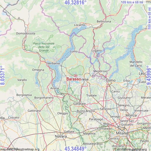
Barasso GPS coordinates[2]
45° 50' 25.728" North, 8° 45' 24.588" East
| Map corner | latitude | longitude |
|---|---|---|
| Upper-left | 46.32816°, | 8.05371° |
| Center: | 45.84048°, | 8.75683° |
| Lower-right: | 45.34849°, | 9.45996° |
| Map W x H: | 108.9×108.9 km | = 67.7×67.7mi |
| max Lat: | 47.04031° ⇑12.6% North |
| Barasso: | 45.84048° |
| min Lat: | ⇓87.4% South 35.50142° |
| min Long | Barasso | max Long |
| 6.69888° | 8.75683° | 18.48682° |
| W 15.3%⇐ | ⇒84.7% E |
Elevation
Elevation of Barasso is 409 m = 1342 ft, and this is 102.3 m = 336 ft above average elevation for this country.
| Max E: |
2085 m = 6841 ft | 28.5% |
| Barasso | 409 m 1342 ft | |
| Avg. | 306.7 m = 1006 ft | |
Min E: |
-4 m = -13 ft | 71.5% |
See also: Italy elevation on elevation.city.
Geographical zone
Barasso is located in North temperate zone (between Tropic of Cancer and the Arctic Circle). Distance of this North polar circle is 2304.2 km =1431.8 mi to North.| Distance of | km | miles | from Barasso |
|---|---|---|---|
| North Pole | 4910.1 | 3051 | to North |
| Arctic Circle | 2304.2 | 1431.8 | to North |
| Tropic Cancer | 2491.1 | 1547.9 | to South |
| Equator | 5097 | 3167.1 | to South |


Nearby cities:
15 places around Barasso: (largest is in red/bold)
• Bardello
4.7 km =2.9 mi,  263°
263°
• Biandronno
4.8 km =3 mi,  230°
230°
• Bodio
5.6 km =3.5 mi,  184°
184°
• Bodio Lomnago
5.8 km =3.6 mi, 184°
• Bregano
5.6 km =3.5 mi,  253°
253°
• Brinzio
5.9 km =3.7 mi,  23°
23°
• Calcinate del Pesce
2.8 km =1.7 mi,  170°
170°
• Casciago
2.2 km =1.4 mi,  113°
113°
• Castello Cabiaglio
5.9 km =3.7 mi,  0°
0°
• Cazzago Brabbia
5.2 km =3.2 mi,  198°
198°
• Comerio
1.2 km =0.7 mi,  277°
277°
• Gavirate
2.4 km =1.5 mi, 260°
• Luvinate
1.2 km =0.7 mi,  94°
94°
• Orino
5.6 km =3.5 mi,  325°
325°
• Varese
5.7 km =3.5 mi, 112°
Sources, notices
• [Note1] Compared only with cities in Italy existing in our database
• [Src1] Map data: © OpenStreetMap contributors (CC-BY-SA)
• [Src2] Other city data from geonames.org with taken over terms of usage.
• [Src3] Geographical zone / Annual Mean Temperature by Robert A. Rohde @ Wikipedia
