Fossalto geodata
Fossalto (Molise) is a seat of a third-order administrative division; located in Italy in Europe/Rome (GMT+2) time zone. With population of 419 people, there are 10204 cities with bigger population in this country. Compared to other cities in Italy, 73.2% of cities are located further ↑North; 83.1% of cities are located further ←West and 78.6% of cities have lower elevation than Fossalto. Note1


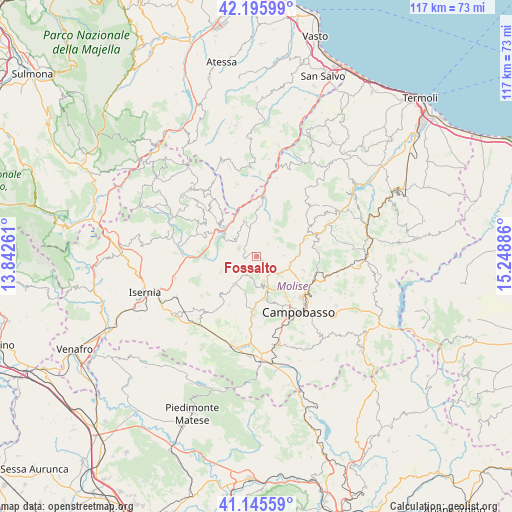
Fossalto GPS coordinates[2]
41° 40' 22.548" North, 14° 32' 44.628" East
| Map corner | latitude | longitude |
|---|---|---|
| Upper-left | 42.19599°, | 13.84261° |
| Center: | 41.67293°, | 14.54573° |
| Lower-right: | 41.14559°, | 15.24886° |
| Map W x H: | 116.8×116.8 km | = 72.6×72.6mi |
| max Lat: | 47.04031° ⇑73.2% North |
| Fossalto: | 41.67293° |
| min Lat: | ⇓26.8% South 35.50142° |
| min Long | Fossalto | max Long |
| 6.69888° | 14.54573° | 18.48682° |
| W 83.1%⇐ | ⇒16.9% E |
Elevation
Elevation of Fossalto is 501 m = 1644 ft, and this is 194.3 m = 637 ft above average elevation for this country.
| Max E: |
2085 m = 6841 ft | 21.4% |
| Fossalto | 501 m 1644 ft | |
| Avg. | 306.7 m = 1006 ft | |
Min E: |
-4 m = -13 ft | 78.6% |
See also: Italy elevation on elevation.city.
Geographical zone
Fossalto is located in North temperate zone (between Tropic of Cancer and the Arctic Circle). Distance of this Northern Tropic circle is 2027.7 km =1260 mi to South.| Distance of | km | miles | from Fossalto |
|---|---|---|---|
| North Pole | 5373.5 | 3338.9 | to North |
| Arctic Circle | 2767.6 | 1719.7 | to North |
| Tropic Cancer | 2027.7 | 1260 | to South |
| Equator | 4633.6 | 2879.2 | to South |


Nearby cities:
15 places around Fossalto: (largest is in red/bold)
• Bagnoli del Trigno
7.9 km =4.9 mi,  294°
294°
• Casalciprano
10.4 km =6.5 mi,  187°
187°
• Castropignano
6.2 km =3.9 mi,  170°
170°
• Duronia
7.3 km =4.5 mi,  256°
256°
• Limosano
6.4 km =4 mi,  87°
87°
• Molise
6.4 km =4 mi,  223°
223°
• Montagano
11.1 km =6.9 mi,  106°
106°
• Oratino
10.5 km =6.5 mi,  157°
157°
• Pietracupa
2.4 km =1.5 mi,  295°
295°
• Salcito
8.7 km =5.4 mi,  340°
340°
• San Biase
6 km =3.7 mi,  38°
38°
• San Pietro in Valle
9.3 km =5.8 mi,  214°
214°
• Sant'Angelo Limosano
5.3 km =3.3 mi,  65°
65°
• Torella del Sannio
4.3 km =2.7 mi, 209°
• Trivento
10.8 km =6.7 mi,  0°
0°
Sources, notices
• [Note1] Compared only with cities in Italy existing in our database
• [Src1] Map data: © OpenStreetMap contributors (CC-BY-SA)
• [Src2] Other city data from geonames.org with taken over terms of usage.
• [Src3] Geographical zone / Annual Mean Temperature by Robert A. Rohde @ Wikipedia
